PeerGalaxy Original Calendar

Welcome to PeerGalaxy Calendar featuring over 336,800+ monthly offerings of FREE telephone- and online-accessible peer support, recovery support, and wellness activities!  Plus 50+ warmlines, helplines, chatlines, and hotlines.  Plus workshops, webinars, job postings, resources, observances, special events, consumer input opportunities and more.

WE ARE PEER FOR YOU!

Click the Accessibility Button on the right side, halfway down in the middle, for enhanced viewing and/or access options!  Click the Translate Button in the lower left corner for language options. 

Your use of this site is subject to the Privacy Policy, Terms and Conditions of Use.

If you have an event to add, email us: [email protected]

Training Opportunities in July 2020
List Provided Courtesy of State of Oregon, Oregon Health Authority
Click here to download PDF Format, 16 pages

Calendar Event Sorting

At the top, the 24/7/365 SAMHSA Disaster Helpline and similar links.

Next, Bundled “All Day” Events

Some organizations (like 12 step recovery programs, AA, NA, AlAnon, etc.) have so many events happening throughout the day that they need to be in a bundled listing to spare endless scrolling.  Often there is a link to look up events by zip code and other criteria.

Lastly, Time-Specific Events

So you can see what’s happening in the next hours, time specific events are tagged and listed by start time from 12:01am early morning to 11:59pm late night.  There can be events and warmlines operating in different time zones, though we try to list all in Oregon’s Pacific Time Zone.

Page Advancement

The calendar displays ~50 listings per page.  To advance to next page with ~50 more listings, click the right arrow in the lower left corner of the calendar


Screenshot image of the page advancing arrows at the bottom of the calendar, lower left corner.
Aug
12
Wed
2026
02 – Resources – OHA – Oregon Health Authority – Cloudy with a chance of sunburn: Protect yourself this Skin Cancer Awareness Month
Aug 12 all-day
02 - Resources - OHA - Oregon Health Authority - Cloudy with a chance of sunburn: Protect yourself this Skin Cancer Awareness Month


OREGON HEALTH AUTHORITY — Skin Cancer Awareness

Public Health Education · Cancer Prevention · Sun Safety

“Even on cloudy days, UV rays are working. So should your sunscreen.”

WHY SUN SAFETY MATTERS IN OREGON

May is Skin Cancer Awareness Month — and Oregon’s weather can be deceiving. Oregon is known for cloudy skies and rain, but the sun’s ultraviolet (UV) rays can still harm your skin year-round. Whether you’re at the coast, hiking in Central Oregon, or spending time in the Willamette Valley, sun protection matters every single day.

In May, the UV Index in Oregon can reach levels as high as 10 (Very High) — meaning unprotected skin can burn in fewer than 20 minutes. Clouds do not block UV rays. Even on overcast days, your skin is at risk.


UNDERSTANDING THE UV INDEX

The UV Index is a daily rating that tells you how strong the sun’s UV rays are. Check the rating before heading outside.

  • 0–2 (Low): Safe for most people.
  • 3–5 (Moderate): Wear sunscreen and sunglasses.
  • 6–7 (High): Seek shade during midday hours.
  • 8–10 (Very High): Extra protection is needed — limit time outdoors during peak hours.


Quick tip: If your shadow is shorter than you are, the sun’s rays are at their strongest. Find shade and reapply sunscreen right away.

Use the EPA UV Index Search Tool to check today’s UV rating for your area before heading outside. Available 24 hours a day · 7 days a week.


HOW TO PROTECT YOURSELF

Good sun safety habits can be simple. Small steps add up and can protect your skin for a lifetime.


  • Use broad-spectrum sunscreen with SPF 30 or higher.
  • Reapply sunscreen every two hours, or after swimming or sweating.
  • Wear hats, sunglasses, and protective clothing when outdoors.
  • Seek shade between 10:00 AM and 4:00 PM PT when UV rays are strongest.
  • Check the daily UV Index before going outside.


CHECK YOUR SKIN EVERY MONTH

Catching skin cancer early can save your life. A monthly self-check takes just a few minutes. Here’s what to look for:

  • New spots or moles.
  • Changes in size, color, or shape of existing moles.
  • Spots that itch, bleed, or don’t heal.
  • Anything that doesn’t look right to you.

If something seems unusual, contact your doctor. Early detection and treatment make a significant difference in outcomes.


ADDITIONAL RESOURCES

Start Seeing Melanoma — Campaign Website — Helps you recognize the early signs of skin cancer with visuals and educational tools. Available 24 hours a day · 7 days a week.

American Cancer Society — Be Safe in the Sun — Comprehensive information on sun safety, UV exposure, and skin cancer prevention. Available 24 hours a day · 7 days a week.

American Cancer Society — Skin Cancer Knowledge Quiz — Test your knowledge and get the facts about skin cancer risk, prevention, and detection. Available 24 hours a day · 7 days a week.

EPA UV Index Applications and Tools — Search the UV Index for your location and plan sun-safe activities. Available 24 hours a day · 7 days a week.


ABOUT OREGON HEALTH AUTHORITY

The Oregon Health Authority (OHA) is Oregon’s primary state health agency, working to protect and improve the health and well-being of all Oregonians. OHA leads public health programs, health policy, and community education initiatives across the state — including cancer prevention, chronic disease management, and environmental health. Oregon Health News is OHA’s public information resource for Oregonians seeking trusted, timely health guidance.

DISCLAIMER: Information is shared as a courtesy and is for educational purposes only. This content is not a substitute for professional medical advice, diagnosis, treatment, or emergency services. If a child or person is in immediate danger, call 911 or contact local law enforcement. For mental health or substance use emergencies, call or text 988 (Suicide & Crisis Lifeline). Consult a qualified medical professional for personalized health guidance. Skin cancer screening and diagnosis must be performed by a licensed healthcare provider.


04 – Resources – Statewide Weather & Fire Conditions Report Active NWS Watches, Warnings & Advisories · Fire, Flood & Coastal Conditions
Aug 12 all-day
04 - Resources -  Statewide Weather & Fire Conditions Report Active NWS Watches, Warnings & Advisories · Fire, Flood & Coastal Conditions


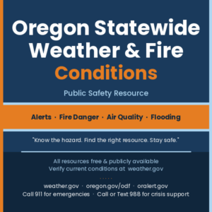
OREGON STATEWIDE WEATHER & FIRE CONDITIONS

Public Safety Resource · Weather Alerts · Fire Danger · Air Quality · Flooding

“Know the hazard. Find the right resource. Stay safe.”

All resources listed are free and publicly available · Verify current conditions directly with official sources below

CALL 911

For anyone experiencing an active wildfire, flooding, or immediate threat to life or property

CALL OR TEXT 988

For anyone in emotional distress or mental health crisis related to a disaster or evacuation · Free · Confidential · 24/7

YOUR FIRST THREE STEPS WHEN A HAZARD IS POSSIBLE

1 · Check NWS Active Alerts for Oregon  NWS Oregon Active Alerts

Every active watch, warning, and advisory in Oregon — in one place. Check here first whenever you hear about a hazard in your area.

2 · Check Your Fire Danger Level and Burn Restrictions  ODF Fire Restrictions Interactive Map

Tap your location on the interactive map to see your local fire danger level and whether any burn restrictions apply. Works on mobile. Check before any outdoor burning — any time of year.

3 · Sign Up for County Emergency Alerts  Oregon Emergency Alert Registration

Register your phone and home address so wildfire, flood, and evacuation alerts reach you directly — without having to check anything. Takes less than two minutes.

NWS ALERT TYPE DEFINITIONS

When a hazard is issued for your area, it will carry one of these labels. Knowing what each term means tells you how urgently to act.

🔴  WARNING

Hazardous conditions are occurring or imminent. Take protective action NOW — do not wait.

🟡  WATCH

Conditions are favorable for a hazard to develop. Prepare now and monitor updates closely.

🟠  ADVISORY

Conditions will be hazardous but below warning thresholds. Use extra caution outdoors.

🔵  SPECIAL WEATHER STATEMENT

Noteworthy conditions that require public awareness but do not meet warning or advisory thresholds. Stay aware and check for updates.

🏖  BEACH HAZARDS STATEMENT

Dangerous ocean or beach conditions — sneaker waves, rip currents, or extreme surf. Stay well back from the water’s edge regardless of how calm the ocean looks.

🔥  RED FLAG WARNING

Critical fire weather: low humidity + high winds + dry fuels = extreme fire danger. No outdoor burning of any kind. Avoid all spark-producing activity.

🌊  SMALL CRAFT ADVISORY

Hazardous conditions for small vessels. Inexperienced mariners should stay off coastal and Columbia River Bar waters until the advisory expires.

💧  FLOOD WATCH

Flooding is possible. Prepare now — know your evacuation route and monitor river gauge levels.

💧  FLOOD WARNING

Flooding is occurring or imminent. Move to higher ground now. Turn Around, Don’t Drown — never drive through a flooded road.

FIRE DANGER LEVELS — WHAT THEY MEAN

The Oregon Department of Forestry uses a five-level fire danger scale. Your local level determines which activities may be restricted on public and private forestlands. Danger levels can vary significantly over short distances — always check your specific location on the ODF map before any outdoor burning or spark-producing activity.

  • LOW

Fires are unlikely to start or spread rapidly. Normal outdoor caution applies.

  • MODERATE

Fires can start and spread under dry or windy conditions. Use caution near any ignition source outdoors.

  • HIGH

Fires start easily and spread quickly. Check ODF burn restrictions before any outdoor burning. Debris fires must be fully extinguished — never left to smolder.

  • VERY HIGH

Fires start very easily from almost any spark. Outdoor burning is typically prohibited. Check ODF restrictions for your specific location before any outdoor activity.

  • EXTREME

Maximum fire danger. Any fire can quickly become uncontrollable. All outdoor burning prohibited. Avoid all spark-producing activity entirely.

Check your current fire danger level and burn restrictions:  ODF Fire Restrictions Interactive Map

OREGON SEASONAL HAZARD GUIDE

Oregon faces different hazards throughout the year. Use this guide to know what to watch for in any given season and which resources to check most closely.

❄  WINTER — December through February

Ice storms and freezing rain in the Willamette Valley · Heavy snow in the Cascades and eastern Oregon · Coastal wind events and large surf · Sneaker waves year-round · River flooding from rain-on-snow events

🌱  SPRING — March through May

Early Red Flag fire weather as fuels dry before green-up · Snowmelt flooding along Cascade-fed rivers · Prescribed burn smoke · High surf and sneaker waves on the coast

🔥  SUMMER — June through September

Wildfire season peaks statewide · Red Flag Warnings common in south-central and eastern Oregon · Smoke events affecting air quality across the state · Extreme heat in the Willamette Valley and eastern Oregon · Lightning-caused fires in the mountains

🍂  FALL — October through November

Wildfires may remain active into October · Coastal wind events return · Early ice and snow in the mountains · Transition back to rainy-season flooding risk · First major wind events of the season

REGIONAL HAZARD CONTEXT

Western Oregon & Portland Metro

Willamette Valley weather is generally mild but can shift quickly. Watch for winter ice storms and wind events that cause widespread power outages, summer heat waves, and river flooding during rain-on-snow events in the mountains. The Columbia River Gorge is a natural wind corridor — conditions there can be dramatically different from surrounding areas.

Oregon Coast

Sneaker waves are the leading cause of ocean drowning deaths on the Oregon coast and occur year-round — including on days when the surf appears completely calm. Stay well back from the water’s edge. Never turn your back on the ocean. Stay off rocks, jetties, and logs at the surf line at all times. Watch for NWS Beach Hazards Statements before any coastal visit. The Columbia River Bar is one of the most hazardous river mouths in North America — always check bar conditions with the U.S. Coast Guard before any crossing attempt.

South-Central Oregon — Lake, Klamath & Harney Counties

This region is among Oregon’s most fire-prone. Red Flag Warnings are common in spring and summer when low humidity, high winds, and dry grass create extreme ignition conditions. The pre-green-up period in late winter and early spring — before new vegetation replaces last year’s dead grass — is particularly dangerous. Even a small spark can start a fast-moving fire. Always check ODF restrictions before any outdoor burning or use of spark-producing equipment.

Central Oregon — Bend, Redmond, Prineville, Madras

Central Oregon’s dry high-desert climate means fire risk arrives early and persists late into the season. Prescribed burns on the Deschutes and Ochoco national forests and the Crooked River National Grassland can produce smoke affecting communities along the Highway 26 and Highway 97 corridors. Check air quality at oregon.gov/deq before extended outdoor activity whenever smoke is visible.

Eastern Oregon

Eastern Oregon faces both wildfire risk and flash flood potential. Summer thunderstorms over the Blue Mountains and Wallowas can produce lightning-caused fires and rapid runoff into steep canyon drainages. Rivers fed by east-slope snowpack — including the John Day, Malheur, Owyhee, and Deschutes — can rise quickly during spring snowmelt events. Check river gauges at water.noaa.gov before recreating near any waterway.

Southern Oregon — Rogue Valley, Medford, Ashland, Grants Pass

Southern Oregon sits in a fire-prone interface zone where forested mountains meet populated valleys. Fire season can begin as early as June and extend into October. Smoke from both Oregon and northern California wildfires regularly affects air quality in late summer. Years with below-average snowpack significantly increase fire risk beginning as early as spring.

WILDFIRE SMOKE & AIR QUALITY GUIDE

Wildfire smoke contains fine particles that penetrate deep into the lungs and cannot be filtered by an ordinary dust mask. Groups at elevated risk include children, older adults, pregnant women, and anyone with heart or lung conditions. Check air quality before any outdoor activity during a smoke event — conditions can change within hours.

Air Quality Index (AQI) — What the Colors Mean

  • GREEN (0–50) — Good

Air quality is satisfactory. Outdoor activity is fine for everyone.

  • YELLOW (51–100) — Moderate

Sensitive groups should consider limiting prolonged outdoor exertion.

  • ORANGE (101–150) — Unhealthy for Sensitive Groups

Children, older adults, and anyone with heart or lung conditions should reduce time outdoors.

  • RED (151–200) — Unhealthy

Everyone should reduce prolonged outdoor exertion. Sensitive groups should remain indoors.

  • PURPLE (201–300) — Very Unhealthy

Avoid all outdoor activity. Keep windows and doors closed.

  • MAROON (301+) — Hazardous

Health emergency conditions. Everyone should stay indoors with windows closed.

Simple indoor air filtration during a smoke event:  Tape a MERV-13 furnace filter to the back of a standard box fan. This creates an effective air cleaner at very low cost and is safe to run with windows closed.

Check current air quality:  Oregon DEQ Air Quality Index  ·  AirNow.gov  ·  OregonAIR Mobile App

NO CELL SERVICE OR INTERNET? USE NOAA WEATHER RADIO

A NOAA Weather Radio receiver broadcasts continuous NWS alerts, weather forecasts, fire weather warnings, and emergency messages 24 hours a day · 7 days a week on 162.400 – 162.550 MHz. It is the most reliable alert system for rural Oregon when cell coverage or internet is unavailable. A dedicated receiver is required — available at hardware and electronics retailers for under $30. Find the transmitter frequency for your location at weather.gov/nwr.

MONITOR & STAY INFORMED — COMPLETE RESOURCE LIST

All resources below are free and publicly available 24 hours a day · 7 days a week unless otherwise noted.

WEATHER — WATCHES, WARNINGS & FORECASTS

NWS Active Alerts — All of Oregon

Every active NWS watch, warning, and advisory currently in effect anywhere in Oregon — in one place. Check here first.

NWS Portland — Western Oregon

Current alerts and forecasts for the Portland metro, Willamette Valley, northern coast, and Columbia River Gorge.

NWS Medford — Southern Oregon

Alerts and forecasts for the Rogue Valley, Klamath Basin, Crater Lake area, and south-central Oregon.

NWS Pendleton — Eastern & Central Oregon

Alerts and forecasts for eastern Oregon, the Blue Mountains, Cascades east slopes, and the central Oregon high desert.

NOAA Marine Forecast — Oregon Coast

Coastal and offshore forecasts, small craft advisories, and Columbia River Bar conditions.

NOAA Weather Radio Frequency Finder

Find your local 162 MHz NOAA Weather Radio frequency. Continuous 24/7 NWS broadcasts — the most reliable alert system when cell coverage or internet fails.

FIRE DANGER, RESTRICTIONS & ACTIVE WILDFIRES

ODF Fire Danger & Burn Restrictions Map

Interactive map — tap or click your location to see your current fire danger level and active burn restrictions. Works on mobile. Check before any outdoor burning.

Oregon Dept. of Forestry — Fire & Weather

Official ODF fire weather forecasts, statewide danger ratings, and fire news and press releases.

Before You Burn — Debris Burning Check

Check daily whether outdoor debris burning is allowed in your area before lighting anything. Debris burning is the leading cause of human-caused wildfires in Oregon.

BLM Oregon & Washington — Fire Restrictions

Fire restrictions for Bureau of Land Management lands. Note: BLM restrictions may differ from ODF restrictions on adjacent land — check both for your location.

InciWeb — Active Oregon Wildfires

Active wildfire locations, acreage, containment status, road closures, and evacuation orders across Oregon.

Northwest Interagency Coordination Center

Regional fire situation reports and preparedness levels for Oregon and Washington.

AIR QUALITY & WILDFIRE SMOKE

Oregon DEQ — Air Quality Index

Real-time statewide air quality readings. Check before outdoor activity during any smoke event — especially for children, older adults, and anyone with heart or lung conditions.

AirNow.gov — Federal Air Quality

Current and forecast AQI by location. Includes smoke forecasts during wildfire events. Available 24 hours a day · 7 days a week.

OregonAIR Mobile App

Free mobile app for real-time Oregon air quality readings and alerts. Available for iOS and Android.

FLOODING & RIVER LEVELS

NOAA River Levels & Flood Monitoring

Live river gauge readings, flood stage forecasts, and inundation maps for rivers across Oregon. Enter any river name or city. Available 24 hours a day · 7 days a week.

EMERGENCY ALERTS & PREPAREDNESS

Oregon Emergency Alerts — Sign Up

Register your phone and address to receive county emergency alerts for wildfires, floods, and evacuations directly — without having to seek them out.

Oregon Office of Emergency Management

Statewide emergency preparedness resources, disaster declarations, and guidance for individuals, families, and communities.

Oregon Emergency Management — Make a Plan

Step-by-step guidance for building a household emergency plan, go-bag, and communication strategy before a disaster strikes.

KEY PHONE NUMBERS

Save these numbers before a disaster occurs. Cell networks may be congested during an active emergency.

Life-Safety Emergency

CALL: 911

For anyone experiencing or witnessing an active wildfire, flooding, structure fire, or any immediate threat to life or property.

Mental Health Crisis Line

CALL OR TEXT: 988

For anyone in emotional distress or mental health crisis related to a disaster or evacuation. Free · Confidential · Available 24 hours a day · 7 days a week.

Oregon Emergency Management — Duty Officer

CALL: 1-503-378-2911

For local emergency managers and public officials requesting state assistance during an active emergency or declared disaster.

NWS Portland — Western Oregon Recorded Forecast

CALL: 503-261-9246

For anyone in the Portland metro, Willamette Valley, or northern coast. Recorded forecast updated several times daily.

NWS Medford — Southern Oregon

CALL: 541-773-1067

For anyone in southern Oregon or the Rogue Valley seeking a current recorded forecast.

NWS Pendleton — Eastern & Central Oregon

CALL: 541-276-4493

For anyone in eastern or central Oregon seeking a current recorded forecast.

Central Oregon Fire Information Line

CALL: 1-800-523-4737

For anyone in central Oregon seeking current fire danger levels, active burn restrictions, or incident information.

NOAA Weather Radio

162.400 – 162.550 MHz  (receiver required)

For anyone in a rural area without reliable cell or internet coverage. A dedicated weather radio receiver is required — available at hardware and electronics retailers. Find your local frequency at weather.gov/nwr. Available 24 hours a day · 7 days a week.

PREPAREDNESS ACTIONS YOU CAN TAKE NOW

Sign Up for Emergency Alerts

Register at Oregon Emergency Alert Registration — oralert.gov to receive county alerts for wildfires, floods, and evacuations directly on your phone. Also enable Wireless Emergency Alerts in your phone’s notification settings — these require no registration and can reach you even without data service.

Know Your Evacuation Route

Identify at least two ways out of your neighborhood before a disaster occurs. One route may be blocked by fire or floodwater. Know where you would go and how you would reach family members if you are separated. In a fast-moving wildfire, there may be very little warning time — have your plan ready now.

Build a Go-Bag

Keep a ready bag near your door or in your vehicle during fire season. Include: prescription medications and medical supplies · copies of important documents · phone charger and backup battery · water and food for three days · cash · a change of clothing · N95 masks for smoke protection. A go-bag prepared in advance saves critical time during an emergency evacuation.

For Outdoor Burns — Check Before You Light

Debris burning is the leading cause of human-caused wildfires in Oregon — and any escaped fire can result in full liability for suppression costs, which can reach millions of dollars. Before any outdoor burn, check BeforeYouBurn.com and the ODF Fire Restrictions Map. When in doubt, do not burn.

Turn Around, Don’t Drown

Never drive through a flooded road — even if it looks passable. Just six inches of moving water can knock a person off their feet. Two feet of water can carry away most vehicles. If a road ahead is flooded, turn around and find another route. Most flood-related deaths in Oregon occur in vehicles.

Check on Neighbors

Older adults, people with disabilities, and those who live alone may not receive alerts or may need help evacuating. Check on neighbors before a known hazard arrives in your area.

DISCLAIMER: Information is shared solely as a public courtesy. All resources listed are publicly available through official government agencies. This document is not a product of, nor endorsed by, the National Weather Service, Oregon Department of Forestry, Oregon Emergency Management, or any other agency listed. Content is subject to change — always verify current conditions directly with official sources before making any decisions. This is not a substitute for official emergency broadcasts, professional weather services, or instructions from local emergency management authorities. If a person is in immediate danger, call 911. For mental health emergencies, call or text 988 (Suicide & Crisis Lifeline) — free · confidential · available 24 hours a day · 7 days a week. All services listed are free and publicly available.


04 – Resources – Autism Resources, Articles, Support
Aug 12 all-day
04 - Resources - Autism Resources, Articles, Support


Autism Resources, Articles, Support

ABOUT AUTISM

Autism spectrum disorder (ASD) is a developmental disability affecting about 1 in 36 children and roughly 2.2% of adults (Centers for Disease Control and Prevention [CDC], 2023). It influences social communication, behavior, sensory processing, and how individuals experience the world. Symptoms and support needs vary widely, which is why it is called a “spectrum” (National Institute of Mental Health [NIMH], 2023).

People with ASD may have challenges with social interaction and communication, engage in repetitive behaviors, show sensory sensitivities, and prefer routines and predictability, with signs typically appearing in early childhood (NIMH, 2023). Causes include neurological differences, genetic factors, and possible environmental influences, while psychological causes have been ruled out (NIMH, 2023).

With appropriate supports and inclusive environments, autistic individuals can thrive in education, work, and community life (Autistic Self Advocacy Network [ASAN], 2023).

Education and School Supports

Special Education and IEPs

Toolkits & Guides

Transition to Adulthood

Key report: https://drexel.edu/~/media/files/autismoutcomes/publications/nair%202022%20intersection.ashx

Employment

Housing

Directories and Resource Lists

  • Searchable Directory of Autism Resources: Providers, education, respite care, therapy, safety, and more.
  • Autism NOW Fact Sheets: Employment, inclusion, relationships, and more (available in English and Spanish).
    https://www.autismnow.org/resources/fact-sheets/

Media and Learning Tools

Community and Advocacy


08 – Observance – OEM – Oregon Department of Emergency Management – May 2026 Wildfire Awareness Month: Emergency Preparedness Campaign
Aug 12 all-day
08 - Observance - OEM - Oregon Department of Emergency Management - May 2026 Wildfire Awareness Month: Emergency Preparedness Campaign


2026 Wildfire Awareness Month: Emergency Preparedness Campaign

Date/Time: May 1–31, 2026 (Available Throughout May)


Oregon is facing one of the driest wildfire seasons in over a decade with nine counties already under emergency drought declarations. The Oregon Department of Emergency Management urges all residents to get ready now by packing go-bags, knowing evacuation routes, signing up for emergency alerts, and ensuring adequate wildfire insurance.

Pack Your Go-Bag: Essential Wildfire Preparedness

A properly prepared go-bag can make the difference between safe evacuation and dangerous delays. Each household member—including pets and livestock—should have an easy-to-carry emergency bag assembled and ready before wildfire season peaks. OEM provides a comprehensive checklist of essential items from water and food supplies to important documents, medications, first aid, flashlights, and backup power sources.

Cost: FREE

Evacuation Planning: Know Your Routes and Communication Strategy

Effective evacuation planning requires knowing multiple exit routes, establishing a family meeting place, identifying transportation for pets and livestock, and developing a communication strategy for when cell towers may be damaged. OEM recommends creating a PACE plan (Primary, Alternate, Contingency, Emergency) for staying connected, including options like Starlink satellite service, satellite communicators, and hand-crank radios.

Additional Support: Red Cross resources available for individuals with disabilities; Ready.gov/pets provides livestock evacuation guidance; Oregon Department of Agriculture offers specialized resources for farmers and ranchers.

Cost: FREE

Understanding Oregon’s Three-Level Evacuation System

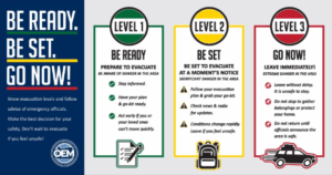
Oregon uses a clear, three-level evacuation alert system: Level 1 (BE READY—Green) means stay aware and prepare; Level 2 (BE SET—Yellow) indicates significant danger and voluntary evacuation is encouraged; Level 3 (GO NOW—Red) means evacuate immediately as extreme danger is present. Understanding these levels and the differences between voluntary and mandatory evacuation orders is critical for family safety.

Format: Online Educational Resource

Cost: FREE

Register for Emergency Alerts and Backup Communication

Sign up with ORAlert.gov to receive location-specific emergency alerts by zip code. Ensure wireless emergency alerts are enabled on your phone and follow local emergency services on social media. Have a backup communication plan in case cell service fails, including contact with loved ones, printed emergency information, and alternative communication methods.

Resources: ORAlert.gov, TripCheck.com, local county emergency management websites

Cost: FREE

Insurance and Recovery Planning: Protect Your Future

Standard renters’ or homeowners’ insurance policies do not cover wildfires, floods, or landslides. Now is the time to verify you have adequate wildfire insurance coverage. Talk with your insurance agent about the right type and amount of coverage. Have a documented recovery plan that identifies what needs to be replaced and how you will recover financially through insurance, savings, loans, and community support.

Cost: FREE planning resources; insurance premiums vary


OEM Wildfire Preparedness Resources

OEM Wildfire Awareness Campaignhttps://wildfire.oregon.gov/prepare · Complete evacuation checklists, preparedness guides, and educational resources

Be2WeeksReady Toolkithttps://www.oregon.gov/oem · Comprehensive emergency preparedness planning tools for families

Wildfire Alert Graphicshttps://www.oregon.gov/oem · Downloadable evacuation level infographics

Media Contact — Phone: 503-934-3310 · Email: [email protected]

External Emergency Preparedness Resources

Red Cross Disaster Preparednesshttps://www.redcross.org · Resources for families, individuals with disabilities, and service animals

Ready.gov Pet Evacuation Planninghttps://www.ready.gov/pets · Pet emergency kits and evacuation strategies

Oregon Department of Agriculture Livestock Resourceshttps://www.oregon.gov/ODA · Livestock evacuation and care resources

Insurance and Financial Recovery Resources

Insurance Institute for Business and Home Safety (IBHS) – Wildfire Readyhttps://www.ibhs.org · Home hardening and insurance resources

Oregon Division of Financial Regulation – Wildfire Insurance Resourceshttps://dfr.oregon.gov · Insurance claim guidance and consumer protections

Crisis Support and Information

988 Suicide & Crisis LifelineCall or text 988 · 24/7 crisis support (especially important during evacuations and recovery)

TripCheck Road Conditionshttps://www.tripcheck.com or call 511 · Real-time evacuation route information


About the Oregon Department of Emergency Management

The Oregon Department of Emergency Management (OEM) was established in 1981 and became a standalone cabinet-level department in July 2022. OEM leads collaborative statewide efforts with local, tribal, state, and federal partners to ensure Oregonians can access help in emergencies and are protected, prepared, and able to recover from disasters regardless of cause.

OEM’s mission is to protect lives, property, and the environment through prevention, preparedness, mitigation, response, and recovery from all hazards. The agency coordinates with over 50 county, city, and tribal emergency management offices across Oregon, awards grant funding to local governments, and supports 18 Emergency Support Functions. OEM prioritizes an equitable and inclusive culture of preparedness that empowers all Oregonians to thrive during crises.

Director: Erin McMahon. Website: https://www.oregon.gov/oem. Phone: 503-934-3310.


CPI – Crisis Prevention Institute – De-escalation and Non-Violent Intervention Training Programs @ Register for Details
Aug 12 all-day


Crisis Prevention Institute offers several trainings including Prevention First, a FREE 30 minute online training:

https://www.crisisprevention.com/our-programs/prevention-first/

De-Escalation for Educators (via YouTube)

https://www.youtube.com/watch?v=7uKGNWEkxvc 

 Additional videos via YouTube:

https://www.youtube.com/@crisisprevention

Online Library:

https://www.crisisprevention.com/library/

Workplace Violence Prevention Handbook (Free PDF download, requires email)

https://institute.crisisprevention.com/Workplace-Violence-Prevention-Handbook/?src=website-wpv-landing


Other trainings and certificate programs (scholarships may be available)

Verbal Intervention

Verbal Intervention (VI) instills the confidence and skills to verbally de‑escalate disruptive behaviors and prevent further escalation. It’s well‑suited to organizations with a hands‑off policy or that require non‑restrictive techniques.

Available as a virtual (Online & Live Virtual) Instructor Certification Program.

More About VI Register Now

Program Features & Benefits:

  • Limit-setting strategies when verbally intervening to de‑escalate defensive behaviors.
  • Recognize opportunities for post‑crisis learning.
  • The effects of trauma and the psychology of the brain on the person in crisis as well as the responding individual.
  • Person-centered to help ensure a consistently inclusive and culturally sensitive approach to a person displaying crisis behavior.
  • Verbal de‑escalation techniques and skills also featured in Nonviolent Crisis Intervention® and NCI With Advanced Physical Skills training.

Nonviolent Crisis Intervention®

Nonviolent Crisis Intervention® (NCI) provides your staff with the skills to safely recognize and respond to everyday crisis situations that may involve more challenging behaviors. NCI training is designed to help you achieve compliance with current legislative initiatives and best practices.

Available as a blended (Online & In-Person) Instructor Certification Program.

More About NCI Register Now

Program Features & Benefits:

  • Safety interventions and disengagement techniques for escalating risk behaviors.
  • Limit-setting strategies when verbally intervening to de-escalate defensive behaviors.
  • Recognize opportunities for post-crisis learning.
  • The effects of trauma and the psychology of the brain on the person in crisis as well as the responding individual.
  • Person-centered to help ensure a consistently inclusive and culturally sensitive approach to a person displaying crisis behavior.

Nonviolent Crisis Intervention® With Advanced Physical Skills

Nonviolent Crisis Intervention® With Advanced Physical Skills (APS) equips your staff with the decision-making skills needed to confidently assess and address risk in the face of complex behaviors. It combines verbal intervention strategies and restrictive interventions with advanced physical skills for the highest-risk scenarios. Instructors can customize training to each staff member’s individual risk level.

Available as a blended (Online, Live Virtual & In-Person) Instructor Certification Program.

More About APS Register Now

Program Features & Benefits:

  • Safe and advanced deceleration, disengagement, and physical intervention techniques for situations involving dangerous behaviors.
  • Intervene in high- and medium-risk situations that don’t require advanced skills.
  • Safety interventions and disengagement techniques for escalating risk behaviors.
  • Limit-setting strategies when verbally intervening to de-escalate defensive behaviors.
  • Recognize opportunities for post-crisis learning.
  • The effects of trauma and the psychology of the brain on the person in crisis as well as the responding individual.
  • Person-centered to help ensure a consistently inclusive and culturally sensitive approach to a person displaying crisis behavior.

Suicide Prevention Training

The Columbia Protocol, also known as the Columbia-Suicide Severity Rating Scale (C-SSRS), supports suicide risk screening through a series of simple, plain-language questions that anyone can ask.

The Columbia Lighthouse Project offers numerous FREE training options for individuals and systems in more than 20 languages. The shortest training takes about 20 minutes, and almost all of them can be completed within an hour. Trainings are not setting specific. Choose the method that works best for you.at this link:

https://cssrs.columbia.edu/training/training-options/


HAMS: Harm Reduction, Abstinence, and Moderation Support – Facebook Group – 24/7 @ Online Via Facebook Live
Aug 12 all-day
HAMS: Harm Reduction, Abstinence, and Moderation Support - Facebook Group - 24/7 @ Online Via Facebook Live

HAMS

Harm reduction, Abstinence, and Moderation Support

24/7

JOIN FACEBOOK GROUP HERE

The acronym HAMS stands for Harm reduction, Abstinence, and Moderation Support. HAMS provides pragmatic strategies to enable individuals to reduce the risks associated with drinking. Alcohol Harm Reduction is non-judgmental–it sees nothing inherently wrong or diseased about recreational intoxication. Alcohol Harm Reduction recognizes that most drinkers have no wish to harm or kill themselves or others.
Alcohol Harm Reduction does not seek to force individuals to change in ways which they do not choose for themselves. Alcohol Harm Reduction respects every person as a unique individual and supports each individual in the goal which he/she has chosen for him/herself. Alcohol Harm Reduction neither promotes nor condemns drinking. Alcohol Harm Reduction supports goals of safer drinking, reduced drinking, or abstinence from alcohol or other substances.
The HAMS Harm Reduction Network provides information and support for people who wish to reduce the harm in their lives caused by the use of alcohol. We support every positive change.
Online harm reduction support groups:
Other Resources:
Students’ Guide to Safe Drinking: https://hams.cc/students
Alcohol Harm Reduction Cheat Sheet: https://hams.cc/hr
Alcohol Moderation Cheat Sheet: https://hams.cc/mods
Alcohol Abstinence Cheat Sheet: https://hams.cc/abs
BETTER IS BETTER!!

POWER ON!!


05 – Línea de ayuda – TL – Trans Lifeline Salvando Vidas – (877) 565-8860 – Lunes – Viernes – 10AM a 6PM PST @ phone
Aug 12 @ 10:00 am – 6:00 pm
05 - Línea de ayuda - TL - Trans Lifeline Salvando Vidas - (877) 565-8860 - Lunes - Viernes - 10AM a 6PM PST @ phone


LÍNEA DIRECTA

Estados Unidos (877) 565-8860

CANADÁ (877) 330-8336

Lunes – Viernes – 10AM a 6PM PST

Línea directa in español

La línea directa de Trans Lifeline es un servicio telefónico de apoyo dirigido por personas transgénero para las personas transgénero y/o que están cuestionando su género. Creemos que el mejor apoyo que las personas Trans pueden recibir es el de los miembros de la comunidad Trans con experiencias de vida compartidas.

Llámanos si necesitas a alguien Trans con quien hablar, incluso si no estás en crisis o no sabes con certeza si eres transgénero.

Marca al (877) 565-8860 en los Estados Unidos o al (877) 330-6366 en Canadá y oprime el #2 para conectarte con operadorxs que hablan español.


Aug
13
Thu
2026
02 – Resources – OHA – Oregon Health Authority – Cloudy with a chance of sunburn: Protect yourself this Skin Cancer Awareness Month
Aug 13 all-day
02 - Resources - OHA - Oregon Health Authority - Cloudy with a chance of sunburn: Protect yourself this Skin Cancer Awareness Month


OREGON HEALTH AUTHORITY — Skin Cancer Awareness

Public Health Education · Cancer Prevention · Sun Safety

“Even on cloudy days, UV rays are working. So should your sunscreen.”

WHY SUN SAFETY MATTERS IN OREGON

May is Skin Cancer Awareness Month — and Oregon’s weather can be deceiving. Oregon is known for cloudy skies and rain, but the sun’s ultraviolet (UV) rays can still harm your skin year-round. Whether you’re at the coast, hiking in Central Oregon, or spending time in the Willamette Valley, sun protection matters every single day.

In May, the UV Index in Oregon can reach levels as high as 10 (Very High) — meaning unprotected skin can burn in fewer than 20 minutes. Clouds do not block UV rays. Even on overcast days, your skin is at risk.


UNDERSTANDING THE UV INDEX

The UV Index is a daily rating that tells you how strong the sun’s UV rays are. Check the rating before heading outside.

  • 0–2 (Low): Safe for most people.
  • 3–5 (Moderate): Wear sunscreen and sunglasses.
  • 6–7 (High): Seek shade during midday hours.
  • 8–10 (Very High): Extra protection is needed — limit time outdoors during peak hours.


Quick tip: If your shadow is shorter than you are, the sun’s rays are at their strongest. Find shade and reapply sunscreen right away.

Use the EPA UV Index Search Tool to check today’s UV rating for your area before heading outside. Available 24 hours a day · 7 days a week.


HOW TO PROTECT YOURSELF

Good sun safety habits can be simple. Small steps add up and can protect your skin for a lifetime.


  • Use broad-spectrum sunscreen with SPF 30 or higher.
  • Reapply sunscreen every two hours, or after swimming or sweating.
  • Wear hats, sunglasses, and protective clothing when outdoors.
  • Seek shade between 10:00 AM and 4:00 PM PT when UV rays are strongest.
  • Check the daily UV Index before going outside.


CHECK YOUR SKIN EVERY MONTH

Catching skin cancer early can save your life. A monthly self-check takes just a few minutes. Here’s what to look for:

  • New spots or moles.
  • Changes in size, color, or shape of existing moles.
  • Spots that itch, bleed, or don’t heal.
  • Anything that doesn’t look right to you.

If something seems unusual, contact your doctor. Early detection and treatment make a significant difference in outcomes.


ADDITIONAL RESOURCES

Start Seeing Melanoma — Campaign Website — Helps you recognize the early signs of skin cancer with visuals and educational tools. Available 24 hours a day · 7 days a week.

American Cancer Society — Be Safe in the Sun — Comprehensive information on sun safety, UV exposure, and skin cancer prevention. Available 24 hours a day · 7 days a week.

American Cancer Society — Skin Cancer Knowledge Quiz — Test your knowledge and get the facts about skin cancer risk, prevention, and detection. Available 24 hours a day · 7 days a week.

EPA UV Index Applications and Tools — Search the UV Index for your location and plan sun-safe activities. Available 24 hours a day · 7 days a week.


ABOUT OREGON HEALTH AUTHORITY

The Oregon Health Authority (OHA) is Oregon’s primary state health agency, working to protect and improve the health and well-being of all Oregonians. OHA leads public health programs, health policy, and community education initiatives across the state — including cancer prevention, chronic disease management, and environmental health. Oregon Health News is OHA’s public information resource for Oregonians seeking trusted, timely health guidance.

DISCLAIMER: Information is shared as a courtesy and is for educational purposes only. This content is not a substitute for professional medical advice, diagnosis, treatment, or emergency services. If a child or person is in immediate danger, call 911 or contact local law enforcement. For mental health or substance use emergencies, call or text 988 (Suicide & Crisis Lifeline). Consult a qualified medical professional for personalized health guidance. Skin cancer screening and diagnosis must be performed by a licensed healthcare provider.


04 – Resources – Statewide Weather & Fire Conditions Report Active NWS Watches, Warnings & Advisories · Fire, Flood & Coastal Conditions
Aug 13 all-day
04 - Resources -  Statewide Weather & Fire Conditions Report Active NWS Watches, Warnings & Advisories · Fire, Flood & Coastal Conditions


OREGON STATEWIDE WEATHER & FIRE CONDITIONS

Public Safety Resource · Weather Alerts · Fire Danger · Air Quality · Flooding

“Know the hazard. Find the right resource. Stay safe.”

All resources listed are free and publicly available · Verify current conditions directly with official sources below

CALL 911

For anyone experiencing an active wildfire, flooding, or immediate threat to life or property

CALL OR TEXT 988

For anyone in emotional distress or mental health crisis related to a disaster or evacuation · Free · Confidential · 24/7

YOUR FIRST THREE STEPS WHEN A HAZARD IS POSSIBLE

1 · Check NWS Active Alerts for Oregon  NWS Oregon Active Alerts

Every active watch, warning, and advisory in Oregon — in one place. Check here first whenever you hear about a hazard in your area.

2 · Check Your Fire Danger Level and Burn Restrictions  ODF Fire Restrictions Interactive Map

Tap your location on the interactive map to see your local fire danger level and whether any burn restrictions apply. Works on mobile. Check before any outdoor burning — any time of year.

3 · Sign Up for County Emergency Alerts  Oregon Emergency Alert Registration

Register your phone and home address so wildfire, flood, and evacuation alerts reach you directly — without having to check anything. Takes less than two minutes.

NWS ALERT TYPE DEFINITIONS

When a hazard is issued for your area, it will carry one of these labels. Knowing what each term means tells you how urgently to act.

🔴  WARNING

Hazardous conditions are occurring or imminent. Take protective action NOW — do not wait.

🟡  WATCH

Conditions are favorable for a hazard to develop. Prepare now and monitor updates closely.

🟠  ADVISORY

Conditions will be hazardous but below warning thresholds. Use extra caution outdoors.

🔵  SPECIAL WEATHER STATEMENT

Noteworthy conditions that require public awareness but do not meet warning or advisory thresholds. Stay aware and check for updates.

🏖  BEACH HAZARDS STATEMENT

Dangerous ocean or beach conditions — sneaker waves, rip currents, or extreme surf. Stay well back from the water’s edge regardless of how calm the ocean looks.

🔥  RED FLAG WARNING

Critical fire weather: low humidity + high winds + dry fuels = extreme fire danger. No outdoor burning of any kind. Avoid all spark-producing activity.

🌊  SMALL CRAFT ADVISORY

Hazardous conditions for small vessels. Inexperienced mariners should stay off coastal and Columbia River Bar waters until the advisory expires.

💧  FLOOD WATCH

Flooding is possible. Prepare now — know your evacuation route and monitor river gauge levels.

💧  FLOOD WARNING

Flooding is occurring or imminent. Move to higher ground now. Turn Around, Don’t Drown — never drive through a flooded road.

FIRE DANGER LEVELS — WHAT THEY MEAN

The Oregon Department of Forestry uses a five-level fire danger scale. Your local level determines which activities may be restricted on public and private forestlands. Danger levels can vary significantly over short distances — always check your specific location on the ODF map before any outdoor burning or spark-producing activity.

  • LOW

Fires are unlikely to start or spread rapidly. Normal outdoor caution applies.

  • MODERATE

Fires can start and spread under dry or windy conditions. Use caution near any ignition source outdoors.

  • HIGH

Fires start easily and spread quickly. Check ODF burn restrictions before any outdoor burning. Debris fires must be fully extinguished — never left to smolder.

  • VERY HIGH

Fires start very easily from almost any spark. Outdoor burning is typically prohibited. Check ODF restrictions for your specific location before any outdoor activity.

  • EXTREME

Maximum fire danger. Any fire can quickly become uncontrollable. All outdoor burning prohibited. Avoid all spark-producing activity entirely.

Check your current fire danger level and burn restrictions:  ODF Fire Restrictions Interactive Map

OREGON SEASONAL HAZARD GUIDE

Oregon faces different hazards throughout the year. Use this guide to know what to watch for in any given season and which resources to check most closely.

❄  WINTER — December through February

Ice storms and freezing rain in the Willamette Valley · Heavy snow in the Cascades and eastern Oregon · Coastal wind events and large surf · Sneaker waves year-round · River flooding from rain-on-snow events

🌱  SPRING — March through May

Early Red Flag fire weather as fuels dry before green-up · Snowmelt flooding along Cascade-fed rivers · Prescribed burn smoke · High surf and sneaker waves on the coast

🔥  SUMMER — June through September

Wildfire season peaks statewide · Red Flag Warnings common in south-central and eastern Oregon · Smoke events affecting air quality across the state · Extreme heat in the Willamette Valley and eastern Oregon · Lightning-caused fires in the mountains

🍂  FALL — October through November

Wildfires may remain active into October · Coastal wind events return · Early ice and snow in the mountains · Transition back to rainy-season flooding risk · First major wind events of the season

REGIONAL HAZARD CONTEXT

Western Oregon & Portland Metro

Willamette Valley weather is generally mild but can shift quickly. Watch for winter ice storms and wind events that cause widespread power outages, summer heat waves, and river flooding during rain-on-snow events in the mountains. The Columbia River Gorge is a natural wind corridor — conditions there can be dramatically different from surrounding areas.

Oregon Coast

Sneaker waves are the leading cause of ocean drowning deaths on the Oregon coast and occur year-round — including on days when the surf appears completely calm. Stay well back from the water’s edge. Never turn your back on the ocean. Stay off rocks, jetties, and logs at the surf line at all times. Watch for NWS Beach Hazards Statements before any coastal visit. The Columbia River Bar is one of the most hazardous river mouths in North America — always check bar conditions with the U.S. Coast Guard before any crossing attempt.

South-Central Oregon — Lake, Klamath & Harney Counties

This region is among Oregon’s most fire-prone. Red Flag Warnings are common in spring and summer when low humidity, high winds, and dry grass create extreme ignition conditions. The pre-green-up period in late winter and early spring — before new vegetation replaces last year’s dead grass — is particularly dangerous. Even a small spark can start a fast-moving fire. Always check ODF restrictions before any outdoor burning or use of spark-producing equipment.

Central Oregon — Bend, Redmond, Prineville, Madras

Central Oregon’s dry high-desert climate means fire risk arrives early and persists late into the season. Prescribed burns on the Deschutes and Ochoco national forests and the Crooked River National Grassland can produce smoke affecting communities along the Highway 26 and Highway 97 corridors. Check air quality at oregon.gov/deq before extended outdoor activity whenever smoke is visible.

Eastern Oregon

Eastern Oregon faces both wildfire risk and flash flood potential. Summer thunderstorms over the Blue Mountains and Wallowas can produce lightning-caused fires and rapid runoff into steep canyon drainages. Rivers fed by east-slope snowpack — including the John Day, Malheur, Owyhee, and Deschutes — can rise quickly during spring snowmelt events. Check river gauges at water.noaa.gov before recreating near any waterway.

Southern Oregon — Rogue Valley, Medford, Ashland, Grants Pass

Southern Oregon sits in a fire-prone interface zone where forested mountains meet populated valleys. Fire season can begin as early as June and extend into October. Smoke from both Oregon and northern California wildfires regularly affects air quality in late summer. Years with below-average snowpack significantly increase fire risk beginning as early as spring.

WILDFIRE SMOKE & AIR QUALITY GUIDE

Wildfire smoke contains fine particles that penetrate deep into the lungs and cannot be filtered by an ordinary dust mask. Groups at elevated risk include children, older adults, pregnant women, and anyone with heart or lung conditions. Check air quality before any outdoor activity during a smoke event — conditions can change within hours.

Air Quality Index (AQI) — What the Colors Mean

  • GREEN (0–50) — Good

Air quality is satisfactory. Outdoor activity is fine for everyone.

  • YELLOW (51–100) — Moderate

Sensitive groups should consider limiting prolonged outdoor exertion.

  • ORANGE (101–150) — Unhealthy for Sensitive Groups

Children, older adults, and anyone with heart or lung conditions should reduce time outdoors.

  • RED (151–200) — Unhealthy

Everyone should reduce prolonged outdoor exertion. Sensitive groups should remain indoors.

  • PURPLE (201–300) — Very Unhealthy

Avoid all outdoor activity. Keep windows and doors closed.

  • MAROON (301+) — Hazardous

Health emergency conditions. Everyone should stay indoors with windows closed.

Simple indoor air filtration during a smoke event:  Tape a MERV-13 furnace filter to the back of a standard box fan. This creates an effective air cleaner at very low cost and is safe to run with windows closed.

Check current air quality:  Oregon DEQ Air Quality Index  ·  AirNow.gov  ·  OregonAIR Mobile App

NO CELL SERVICE OR INTERNET? USE NOAA WEATHER RADIO

A NOAA Weather Radio receiver broadcasts continuous NWS alerts, weather forecasts, fire weather warnings, and emergency messages 24 hours a day · 7 days a week on 162.400 – 162.550 MHz. It is the most reliable alert system for rural Oregon when cell coverage or internet is unavailable. A dedicated receiver is required — available at hardware and electronics retailers for under $30. Find the transmitter frequency for your location at weather.gov/nwr.

MONITOR & STAY INFORMED — COMPLETE RESOURCE LIST

All resources below are free and publicly available 24 hours a day · 7 days a week unless otherwise noted.

WEATHER — WATCHES, WARNINGS & FORECASTS

NWS Active Alerts — All of Oregon

Every active NWS watch, warning, and advisory currently in effect anywhere in Oregon — in one place. Check here first.

NWS Portland — Western Oregon

Current alerts and forecasts for the Portland metro, Willamette Valley, northern coast, and Columbia River Gorge.

NWS Medford — Southern Oregon

Alerts and forecasts for the Rogue Valley, Klamath Basin, Crater Lake area, and south-central Oregon.

NWS Pendleton — Eastern & Central Oregon

Alerts and forecasts for eastern Oregon, the Blue Mountains, Cascades east slopes, and the central Oregon high desert.

NOAA Marine Forecast — Oregon Coast

Coastal and offshore forecasts, small craft advisories, and Columbia River Bar conditions.

NOAA Weather Radio Frequency Finder

Find your local 162 MHz NOAA Weather Radio frequency. Continuous 24/7 NWS broadcasts — the most reliable alert system when cell coverage or internet fails.

FIRE DANGER, RESTRICTIONS & ACTIVE WILDFIRES

ODF Fire Danger & Burn Restrictions Map

Interactive map — tap or click your location to see your current fire danger level and active burn restrictions. Works on mobile. Check before any outdoor burning.

Oregon Dept. of Forestry — Fire & Weather

Official ODF fire weather forecasts, statewide danger ratings, and fire news and press releases.

Before You Burn — Debris Burning Check

Check daily whether outdoor debris burning is allowed in your area before lighting anything. Debris burning is the leading cause of human-caused wildfires in Oregon.

BLM Oregon & Washington — Fire Restrictions

Fire restrictions for Bureau of Land Management lands. Note: BLM restrictions may differ from ODF restrictions on adjacent land — check both for your location.

InciWeb — Active Oregon Wildfires

Active wildfire locations, acreage, containment status, road closures, and evacuation orders across Oregon.

Northwest Interagency Coordination Center

Regional fire situation reports and preparedness levels for Oregon and Washington.

AIR QUALITY & WILDFIRE SMOKE

Oregon DEQ — Air Quality Index

Real-time statewide air quality readings. Check before outdoor activity during any smoke event — especially for children, older adults, and anyone with heart or lung conditions.

AirNow.gov — Federal Air Quality

Current and forecast AQI by location. Includes smoke forecasts during wildfire events. Available 24 hours a day · 7 days a week.

OregonAIR Mobile App

Free mobile app for real-time Oregon air quality readings and alerts. Available for iOS and Android.

FLOODING & RIVER LEVELS

NOAA River Levels & Flood Monitoring

Live river gauge readings, flood stage forecasts, and inundation maps for rivers across Oregon. Enter any river name or city. Available 24 hours a day · 7 days a week.

EMERGENCY ALERTS & PREPAREDNESS

Oregon Emergency Alerts — Sign Up

Register your phone and address to receive county emergency alerts for wildfires, floods, and evacuations directly — without having to seek them out.

Oregon Office of Emergency Management

Statewide emergency preparedness resources, disaster declarations, and guidance for individuals, families, and communities.

Oregon Emergency Management — Make a Plan

Step-by-step guidance for building a household emergency plan, go-bag, and communication strategy before a disaster strikes.

KEY PHONE NUMBERS

Save these numbers before a disaster occurs. Cell networks may be congested during an active emergency.

Life-Safety Emergency

CALL: 911

For anyone experiencing or witnessing an active wildfire, flooding, structure fire, or any immediate threat to life or property.

Mental Health Crisis Line

CALL OR TEXT: 988

For anyone in emotional distress or mental health crisis related to a disaster or evacuation. Free · Confidential · Available 24 hours a day · 7 days a week.

Oregon Emergency Management — Duty Officer

CALL: 1-503-378-2911

For local emergency managers and public officials requesting state assistance during an active emergency or declared disaster.

NWS Portland — Western Oregon Recorded Forecast

CALL: 503-261-9246

For anyone in the Portland metro, Willamette Valley, or northern coast. Recorded forecast updated several times daily.

NWS Medford — Southern Oregon

CALL: 541-773-1067

For anyone in southern Oregon or the Rogue Valley seeking a current recorded forecast.

NWS Pendleton — Eastern & Central Oregon

CALL: 541-276-4493

For anyone in eastern or central Oregon seeking a current recorded forecast.

Central Oregon Fire Information Line

CALL: 1-800-523-4737

For anyone in central Oregon seeking current fire danger levels, active burn restrictions, or incident information.

NOAA Weather Radio

162.400 – 162.550 MHz  (receiver required)

For anyone in a rural area without reliable cell or internet coverage. A dedicated weather radio receiver is required — available at hardware and electronics retailers. Find your local frequency at weather.gov/nwr. Available 24 hours a day · 7 days a week.

PREPAREDNESS ACTIONS YOU CAN TAKE NOW

Sign Up for Emergency Alerts

Register at Oregon Emergency Alert Registration — oralert.gov to receive county alerts for wildfires, floods, and evacuations directly on your phone. Also enable Wireless Emergency Alerts in your phone’s notification settings — these require no registration and can reach you even without data service.

Know Your Evacuation Route

Identify at least two ways out of your neighborhood before a disaster occurs. One route may be blocked by fire or floodwater. Know where you would go and how you would reach family members if you are separated. In a fast-moving wildfire, there may be very little warning time — have your plan ready now.

Build a Go-Bag

Keep a ready bag near your door or in your vehicle during fire season. Include: prescription medications and medical supplies · copies of important documents · phone charger and backup battery · water and food for three days · cash · a change of clothing · N95 masks for smoke protection. A go-bag prepared in advance saves critical time during an emergency evacuation.

For Outdoor Burns — Check Before You Light

Debris burning is the leading cause of human-caused wildfires in Oregon — and any escaped fire can result in full liability for suppression costs, which can reach millions of dollars. Before any outdoor burn, check BeforeYouBurn.com and the ODF Fire Restrictions Map. When in doubt, do not burn.

Turn Around, Don’t Drown

Never drive through a flooded road — even if it looks passable. Just six inches of moving water can knock a person off their feet. Two feet of water can carry away most vehicles. If a road ahead is flooded, turn around and find another route. Most flood-related deaths in Oregon occur in vehicles.

Check on Neighbors

Older adults, people with disabilities, and those who live alone may not receive alerts or may need help evacuating. Check on neighbors before a known hazard arrives in your area.

DISCLAIMER: Information is shared solely as a public courtesy. All resources listed are publicly available through official government agencies. This document is not a product of, nor endorsed by, the National Weather Service, Oregon Department of Forestry, Oregon Emergency Management, or any other agency listed. Content is subject to change — always verify current conditions directly with official sources before making any decisions. This is not a substitute for official emergency broadcasts, professional weather services, or instructions from local emergency management authorities. If a person is in immediate danger, call 911. For mental health emergencies, call or text 988 (Suicide & Crisis Lifeline) — free · confidential · available 24 hours a day · 7 days a week. All services listed are free and publicly available.


04 – Resources – Autism Resources, Articles, Support
Aug 13 all-day
04 - Resources - Autism Resources, Articles, Support


Autism Resources, Articles, Support

ABOUT AUTISM

Autism spectrum disorder (ASD) is a developmental disability affecting about 1 in 36 children and roughly 2.2% of adults (Centers for Disease Control and Prevention [CDC], 2023). It influences social communication, behavior, sensory processing, and how individuals experience the world. Symptoms and support needs vary widely, which is why it is called a “spectrum” (National Institute of Mental Health [NIMH], 2023).

People with ASD may have challenges with social interaction and communication, engage in repetitive behaviors, show sensory sensitivities, and prefer routines and predictability, with signs typically appearing in early childhood (NIMH, 2023). Causes include neurological differences, genetic factors, and possible environmental influences, while psychological causes have been ruled out (NIMH, 2023).

With appropriate supports and inclusive environments, autistic individuals can thrive in education, work, and community life (Autistic Self Advocacy Network [ASAN], 2023).

Education and School Supports

Special Education and IEPs

Toolkits & Guides

Transition to Adulthood

Key report: https://drexel.edu/~/media/files/autismoutcomes/publications/nair%202022%20intersection.ashx

Employment

Housing

Directories and Resource Lists

  • Searchable Directory of Autism Resources: Providers, education, respite care, therapy, safety, and more.
  • Autism NOW Fact Sheets: Employment, inclusion, relationships, and more (available in English and Spanish).
    https://www.autismnow.org/resources/fact-sheets/

Media and Learning Tools

Community and Advocacy


08 – Observance – OEM – Oregon Department of Emergency Management – May 2026 Wildfire Awareness Month: Emergency Preparedness Campaign
Aug 13 all-day
08 - Observance - OEM - Oregon Department of Emergency Management - May 2026 Wildfire Awareness Month: Emergency Preparedness Campaign


2026 Wildfire Awareness Month: Emergency Preparedness Campaign

Date/Time: May 1–31, 2026 (Available Throughout May)


Oregon is facing one of the driest wildfire seasons in over a decade with nine counties already under emergency drought declarations. The Oregon Department of Emergency Management urges all residents to get ready now by packing go-bags, knowing evacuation routes, signing up for emergency alerts, and ensuring adequate wildfire insurance.

Pack Your Go-Bag: Essential Wildfire Preparedness

A properly prepared go-bag can make the difference between safe evacuation and dangerous delays. Each household member—including pets and livestock—should have an easy-to-carry emergency bag assembled and ready before wildfire season peaks. OEM provides a comprehensive checklist of essential items from water and food supplies to important documents, medications, first aid, flashlights, and backup power sources.

Cost: FREE

Evacuation Planning: Know Your Routes and Communication Strategy

Effective evacuation planning requires knowing multiple exit routes, establishing a family meeting place, identifying transportation for pets and livestock, and developing a communication strategy for when cell towers may be damaged. OEM recommends creating a PACE plan (Primary, Alternate, Contingency, Emergency) for staying connected, including options like Starlink satellite service, satellite communicators, and hand-crank radios.

Additional Support: Red Cross resources available for individuals with disabilities; Ready.gov/pets provides livestock evacuation guidance; Oregon Department of Agriculture offers specialized resources for farmers and ranchers.

Cost: FREE

Understanding Oregon’s Three-Level Evacuation System

Oregon uses a clear, three-level evacuation alert system: Level 1 (BE READY—Green) means stay aware and prepare; Level 2 (BE SET—Yellow) indicates significant danger and voluntary evacuation is encouraged; Level 3 (GO NOW—Red) means evacuate immediately as extreme danger is present. Understanding these levels and the differences between voluntary and mandatory evacuation orders is critical for family safety.

Format: Online Educational Resource

Cost: FREE

Register for Emergency Alerts and Backup Communication

Sign up with ORAlert.gov to receive location-specific emergency alerts by zip code. Ensure wireless emergency alerts are enabled on your phone and follow local emergency services on social media. Have a backup communication plan in case cell service fails, including contact with loved ones, printed emergency information, and alternative communication methods.

Resources: ORAlert.gov, TripCheck.com, local county emergency management websites

Cost: FREE

Insurance and Recovery Planning: Protect Your Future

Standard renters’ or homeowners’ insurance policies do not cover wildfires, floods, or landslides. Now is the time to verify you have adequate wildfire insurance coverage. Talk with your insurance agent about the right type and amount of coverage. Have a documented recovery plan that identifies what needs to be replaced and how you will recover financially through insurance, savings, loans, and community support.

Cost: FREE planning resources; insurance premiums vary


OEM Wildfire Preparedness Resources

OEM Wildfire Awareness Campaignhttps://wildfire.oregon.gov/prepare · Complete evacuation checklists, preparedness guides, and educational resources

Be2WeeksReady Toolkithttps://www.oregon.gov/oem · Comprehensive emergency preparedness planning tools for families

Wildfire Alert Graphicshttps://www.oregon.gov/oem · Downloadable evacuation level infographics

Media Contact — Phone: 503-934-3310 · Email: [email protected]

External Emergency Preparedness Resources

Red Cross Disaster Preparednesshttps://www.redcross.org · Resources for families, individuals with disabilities, and service animals

Ready.gov Pet Evacuation Planninghttps://www.ready.gov/pets · Pet emergency kits and evacuation strategies

Oregon Department of Agriculture Livestock Resourceshttps://www.oregon.gov/ODA · Livestock evacuation and care resources

Insurance and Financial Recovery Resources

Insurance Institute for Business and Home Safety (IBHS) – Wildfire Readyhttps://www.ibhs.org · Home hardening and insurance resources

Oregon Division of Financial Regulation – Wildfire Insurance Resourceshttps://dfr.oregon.gov · Insurance claim guidance and consumer protections

Crisis Support and Information

988 Suicide & Crisis LifelineCall or text 988 · 24/7 crisis support (especially important during evacuations and recovery)

TripCheck Road Conditionshttps://www.tripcheck.com or call 511 · Real-time evacuation route information


About the Oregon Department of Emergency Management

The Oregon Department of Emergency Management (OEM) was established in 1981 and became a standalone cabinet-level department in July 2022. OEM leads collaborative statewide efforts with local, tribal, state, and federal partners to ensure Oregonians can access help in emergencies and are protected, prepared, and able to recover from disasters regardless of cause.

OEM’s mission is to protect lives, property, and the environment through prevention, preparedness, mitigation, response, and recovery from all hazards. The agency coordinates with over 50 county, city, and tribal emergency management offices across Oregon, awards grant funding to local governments, and supports 18 Emergency Support Functions. OEM prioritizes an equitable and inclusive culture of preparedness that empowers all Oregonians to thrive during crises.

Director: Erin McMahon. Website: https://www.oregon.gov/oem. Phone: 503-934-3310.


CPI – Crisis Prevention Institute – De-escalation and Non-Violent Intervention Training Programs @ Register for Details
Aug 13 all-day


Crisis Prevention Institute offers several trainings including Prevention First, a FREE 30 minute online training:

https://www.crisisprevention.com/our-programs/prevention-first/

De-Escalation for Educators (via YouTube)

https://www.youtube.com/watch?v=7uKGNWEkxvc 

 Additional videos via YouTube:

https://www.youtube.com/@crisisprevention

Online Library:

https://www.crisisprevention.com/library/

Workplace Violence Prevention Handbook (Free PDF download, requires email)

https://institute.crisisprevention.com/Workplace-Violence-Prevention-Handbook/?src=website-wpv-landing


Other trainings and certificate programs (scholarships may be available)

Verbal Intervention

Verbal Intervention (VI) instills the confidence and skills to verbally de‑escalate disruptive behaviors and prevent further escalation. It’s well‑suited to organizations with a hands‑off policy or that require non‑restrictive techniques.

Available as a virtual (Online & Live Virtual) Instructor Certification Program.

More About VI Register Now

Program Features & Benefits:

  • Limit-setting strategies when verbally intervening to de‑escalate defensive behaviors.
  • Recognize opportunities for post‑crisis learning.
  • The effects of trauma and the psychology of the brain on the person in crisis as well as the responding individual.
  • Person-centered to help ensure a consistently inclusive and culturally sensitive approach to a person displaying crisis behavior.
  • Verbal de‑escalation techniques and skills also featured in Nonviolent Crisis Intervention® and NCI With Advanced Physical Skills training.

Nonviolent Crisis Intervention®

Nonviolent Crisis Intervention® (NCI) provides your staff with the skills to safely recognize and respond to everyday crisis situations that may involve more challenging behaviors. NCI training is designed to help you achieve compliance with current legislative initiatives and best practices.

Available as a blended (Online & In-Person) Instructor Certification Program.

More About NCI Register Now

Program Features & Benefits:

  • Safety interventions and disengagement techniques for escalating risk behaviors.
  • Limit-setting strategies when verbally intervening to de-escalate defensive behaviors.
  • Recognize opportunities for post-crisis learning.
  • The effects of trauma and the psychology of the brain on the person in crisis as well as the responding individual.
  • Person-centered to help ensure a consistently inclusive and culturally sensitive approach to a person displaying crisis behavior.

Nonviolent Crisis Intervention® With Advanced Physical Skills

Nonviolent Crisis Intervention® With Advanced Physical Skills (APS) equips your staff with the decision-making skills needed to confidently assess and address risk in the face of complex behaviors. It combines verbal intervention strategies and restrictive interventions with advanced physical skills for the highest-risk scenarios. Instructors can customize training to each staff member’s individual risk level.

Available as a blended (Online, Live Virtual & In-Person) Instructor Certification Program.

More About APS Register Now

Program Features & Benefits:

  • Safe and advanced deceleration, disengagement, and physical intervention techniques for situations involving dangerous behaviors.
  • Intervene in high- and medium-risk situations that don’t require advanced skills.
  • Safety interventions and disengagement techniques for escalating risk behaviors.
  • Limit-setting strategies when verbally intervening to de-escalate defensive behaviors.
  • Recognize opportunities for post-crisis learning.
  • The effects of trauma and the psychology of the brain on the person in crisis as well as the responding individual.
  • Person-centered to help ensure a consistently inclusive and culturally sensitive approach to a person displaying crisis behavior.

Suicide Prevention Training

The Columbia Protocol, also known as the Columbia-Suicide Severity Rating Scale (C-SSRS), supports suicide risk screening through a series of simple, plain-language questions that anyone can ask.

The Columbia Lighthouse Project offers numerous FREE training options for individuals and systems in more than 20 languages. The shortest training takes about 20 minutes, and almost all of them can be completed within an hour. Trainings are not setting specific. Choose the method that works best for you.at this link:

https://cssrs.columbia.edu/training/training-options/


HAMS: Harm Reduction, Abstinence, and Moderation Support – Facebook Group – 24/7 @ Online Via Facebook Live
Aug 13 all-day
HAMS: Harm Reduction, Abstinence, and Moderation Support - Facebook Group - 24/7 @ Online Via Facebook Live

HAMS

Harm reduction, Abstinence, and Moderation Support

24/7

JOIN FACEBOOK GROUP HERE

The acronym HAMS stands for Harm reduction, Abstinence, and Moderation Support. HAMS provides pragmatic strategies to enable individuals to reduce the risks associated with drinking. Alcohol Harm Reduction is non-judgmental–it sees nothing inherently wrong or diseased about recreational intoxication. Alcohol Harm Reduction recognizes that most drinkers have no wish to harm or kill themselves or others.
Alcohol Harm Reduction does not seek to force individuals to change in ways which they do not choose for themselves. Alcohol Harm Reduction respects every person as a unique individual and supports each individual in the goal which he/she has chosen for him/herself. Alcohol Harm Reduction neither promotes nor condemns drinking. Alcohol Harm Reduction supports goals of safer drinking, reduced drinking, or abstinence from alcohol or other substances.
The HAMS Harm Reduction Network provides information and support for people who wish to reduce the harm in their lives caused by the use of alcohol. We support every positive change.
Online harm reduction support groups:
Other Resources:
Students’ Guide to Safe Drinking: https://hams.cc/students
Alcohol Harm Reduction Cheat Sheet: https://hams.cc/hr
Alcohol Moderation Cheat Sheet: https://hams.cc/mods
Alcohol Abstinence Cheat Sheet: https://hams.cc/abs
BETTER IS BETTER!!

POWER ON!!


05 – Línea de ayuda – TL – Trans Lifeline Salvando Vidas – (877) 565-8860 – Lunes – Viernes – 10AM a 6PM PST @ phone
Aug 13 @ 10:00 am – 6:00 pm
05 - Línea de ayuda - TL - Trans Lifeline Salvando Vidas - (877) 565-8860 - Lunes - Viernes - 10AM a 6PM PST @ phone


LÍNEA DIRECTA

Estados Unidos (877) 565-8860

CANADÁ (877) 330-8336

Lunes – Viernes – 10AM a 6PM PST

Línea directa in español

La línea directa de Trans Lifeline es un servicio telefónico de apoyo dirigido por personas transgénero para las personas transgénero y/o que están cuestionando su género. Creemos que el mejor apoyo que las personas Trans pueden recibir es el de los miembros de la comunidad Trans con experiencias de vida compartidas.

Llámanos si necesitas a alguien Trans con quien hablar, incluso si no estás en crisis o no sabes con certeza si eres transgénero.

Marca al (877) 565-8860 en los Estados Unidos o al (877) 330-6366 en Canadá y oprime el #2 para conectarte con operadorxs que hablan español.


Aug
14
Fri
2026
02 – Resources – OHA – Oregon Health Authority – Cloudy with a chance of sunburn: Protect yourself this Skin Cancer Awareness Month
Aug 14 all-day
02 - Resources - OHA - Oregon Health Authority - Cloudy with a chance of sunburn: Protect yourself this Skin Cancer Awareness Month


OREGON HEALTH AUTHORITY — Skin Cancer Awareness

Public Health Education · Cancer Prevention · Sun Safety

“Even on cloudy days, UV rays are working. So should your sunscreen.”

WHY SUN SAFETY MATTERS IN OREGON

May is Skin Cancer Awareness Month — and Oregon’s weather can be deceiving. Oregon is known for cloudy skies and rain, but the sun’s ultraviolet (UV) rays can still harm your skin year-round. Whether you’re at the coast, hiking in Central Oregon, or spending time in the Willamette Valley, sun protection matters every single day.

In May, the UV Index in Oregon can reach levels as high as 10 (Very High) — meaning unprotected skin can burn in fewer than 20 minutes. Clouds do not block UV rays. Even on overcast days, your skin is at risk.


UNDERSTANDING THE UV INDEX

The UV Index is a daily rating that tells you how strong the sun’s UV rays are. Check the rating before heading outside.

  • 0–2 (Low): Safe for most people.
  • 3–5 (Moderate): Wear sunscreen and sunglasses.
  • 6–7 (High): Seek shade during midday hours.
  • 8–10 (Very High): Extra protection is needed — limit time outdoors during peak hours.


Quick tip: If your shadow is shorter than you are, the sun’s rays are at their strongest. Find shade and reapply sunscreen right away.

Use the EPA UV Index Search Tool to check today’s UV rating for your area before heading outside. Available 24 hours a day · 7 days a week.


HOW TO PROTECT YOURSELF

Good sun safety habits can be simple. Small steps add up and can protect your skin for a lifetime.


  • Use broad-spectrum sunscreen with SPF 30 or higher.
  • Reapply sunscreen every two hours, or after swimming or sweating.
  • Wear hats, sunglasses, and protective clothing when outdoors.
  • Seek shade between 10:00 AM and 4:00 PM PT when UV rays are strongest.
  • Check the daily UV Index before going outside.


CHECK YOUR SKIN EVERY MONTH

Catching skin cancer early can save your life. A monthly self-check takes just a few minutes. Here’s what to look for:

  • New spots or moles.
  • Changes in size, color, or shape of existing moles.
  • Spots that itch, bleed, or don’t heal.
  • Anything that doesn’t look right to you.

If something seems unusual, contact your doctor. Early detection and treatment make a significant difference in outcomes.


ADDITIONAL RESOURCES

Start Seeing Melanoma — Campaign Website — Helps you recognize the early signs of skin cancer with visuals and educational tools. Available 24 hours a day · 7 days a week.

American Cancer Society — Be Safe in the Sun — Comprehensive information on sun safety, UV exposure, and skin cancer prevention. Available 24 hours a day · 7 days a week.

American Cancer Society — Skin Cancer Knowledge Quiz — Test your knowledge and get the facts about skin cancer risk, prevention, and detection. Available 24 hours a day · 7 days a week.

EPA UV Index Applications and Tools — Search the UV Index for your location and plan sun-safe activities. Available 24 hours a day · 7 days a week.


ABOUT OREGON HEALTH AUTHORITY

The Oregon Health Authority (OHA) is Oregon’s primary state health agency, working to protect and improve the health and well-being of all Oregonians. OHA leads public health programs, health policy, and community education initiatives across the state — including cancer prevention, chronic disease management, and environmental health. Oregon Health News is OHA’s public information resource for Oregonians seeking trusted, timely health guidance.

DISCLAIMER: Information is shared as a courtesy and is for educational purposes only. This content is not a substitute for professional medical advice, diagnosis, treatment, or emergency services. If a child or person is in immediate danger, call 911 or contact local law enforcement. For mental health or substance use emergencies, call or text 988 (Suicide & Crisis Lifeline). Consult a qualified medical professional for personalized health guidance. Skin cancer screening and diagnosis must be performed by a licensed healthcare provider.


04 – Resources – Statewide Weather & Fire Conditions Report Active NWS Watches, Warnings & Advisories · Fire, Flood & Coastal Conditions
Aug 14 all-day
04 - Resources -  Statewide Weather & Fire Conditions Report Active NWS Watches, Warnings & Advisories · Fire, Flood & Coastal Conditions


OREGON STATEWIDE WEATHER & FIRE CONDITIONS

Public Safety Resource · Weather Alerts · Fire Danger · Air Quality · Flooding

“Know the hazard. Find the right resource. Stay safe.”

All resources listed are free and publicly available · Verify current conditions directly with official sources below

CALL 911

For anyone experiencing an active wildfire, flooding, or immediate threat to life or property

CALL OR TEXT 988

For anyone in emotional distress or mental health crisis related to a disaster or evacuation · Free · Confidential · 24/7

YOUR FIRST THREE STEPS WHEN A HAZARD IS POSSIBLE

1 · Check NWS Active Alerts for Oregon  NWS Oregon Active Alerts

Every active watch, warning, and advisory in Oregon — in one place. Check here first whenever you hear about a hazard in your area.

2 · Check Your Fire Danger Level and Burn Restrictions  ODF Fire Restrictions Interactive Map

Tap your location on the interactive map to see your local fire danger level and whether any burn restrictions apply. Works on mobile. Check before any outdoor burning — any time of year.

3 · Sign Up for County Emergency Alerts  Oregon Emergency Alert Registration

Register your phone and home address so wildfire, flood, and evacuation alerts reach you directly — without having to check anything. Takes less than two minutes.

NWS ALERT TYPE DEFINITIONS

When a hazard is issued for your area, it will carry one of these labels. Knowing what each term means tells you how urgently to act.

🔴  WARNING

Hazardous conditions are occurring or imminent. Take protective action NOW — do not wait.

🟡  WATCH

Conditions are favorable for a hazard to develop. Prepare now and monitor updates closely.

🟠  ADVISORY

Conditions will be hazardous but below warning thresholds. Use extra caution outdoors.

🔵  SPECIAL WEATHER STATEMENT

Noteworthy conditions that require public awareness but do not meet warning or advisory thresholds. Stay aware and check for updates.

🏖  BEACH HAZARDS STATEMENT

Dangerous ocean or beach conditions — sneaker waves, rip currents, or extreme surf. Stay well back from the water’s edge regardless of how calm the ocean looks.

🔥  RED FLAG WARNING

Critical fire weather: low humidity + high winds + dry fuels = extreme fire danger. No outdoor burning of any kind. Avoid all spark-producing activity.

🌊  SMALL CRAFT ADVISORY

Hazardous conditions for small vessels. Inexperienced mariners should stay off coastal and Columbia River Bar waters until the advisory expires.

💧  FLOOD WATCH

Flooding is possible. Prepare now — know your evacuation route and monitor river gauge levels.

💧  FLOOD WARNING

Flooding is occurring or imminent. Move to higher ground now. Turn Around, Don’t Drown — never drive through a flooded road.

FIRE DANGER LEVELS — WHAT THEY MEAN

The Oregon Department of Forestry uses a five-level fire danger scale. Your local level determines which activities may be restricted on public and private forestlands. Danger levels can vary significantly over short distances — always check your specific location on the ODF map before any outdoor burning or spark-producing activity.

  • LOW

Fires are unlikely to start or spread rapidly. Normal outdoor caution applies.

  • MODERATE

Fires can start and spread under dry or windy conditions. Use caution near any ignition source outdoors.

  • HIGH

Fires start easily and spread quickly. Check ODF burn restrictions before any outdoor burning. Debris fires must be fully extinguished — never left to smolder.

  • VERY HIGH

Fires start very easily from almost any spark. Outdoor burning is typically prohibited. Check ODF restrictions for your specific location before any outdoor activity.

  • EXTREME

Maximum fire danger. Any fire can quickly become uncontrollable. All outdoor burning prohibited. Avoid all spark-producing activity entirely.

Check your current fire danger level and burn restrictions:  ODF Fire Restrictions Interactive Map

OREGON SEASONAL HAZARD GUIDE

Oregon faces different hazards throughout the year. Use this guide to know what to watch for in any given season and which resources to check most closely.

❄  WINTER — December through February

Ice storms and freezing rain in the Willamette Valley · Heavy snow in the Cascades and eastern Oregon · Coastal wind events and large surf · Sneaker waves year-round · River flooding from rain-on-snow events

🌱  SPRING — March through May

Early Red Flag fire weather as fuels dry before green-up · Snowmelt flooding along Cascade-fed rivers · Prescribed burn smoke · High surf and sneaker waves on the coast

🔥  SUMMER — June through September

Wildfire season peaks statewide · Red Flag Warnings common in south-central and eastern Oregon · Smoke events affecting air quality across the state · Extreme heat in the Willamette Valley and eastern Oregon · Lightning-caused fires in the mountains

🍂  FALL — October through November

Wildfires may remain active into October · Coastal wind events return · Early ice and snow in the mountains · Transition back to rainy-season flooding risk · First major wind events of the season

REGIONAL HAZARD CONTEXT

Western Oregon & Portland Metro

Willamette Valley weather is generally mild but can shift quickly. Watch for winter ice storms and wind events that cause widespread power outages, summer heat waves, and river flooding during rain-on-snow events in the mountains. The Columbia River Gorge is a natural wind corridor — conditions there can be dramatically different from surrounding areas.

Oregon Coast

Sneaker waves are the leading cause of ocean drowning deaths on the Oregon coast and occur year-round — including on days when the surf appears completely calm. Stay well back from the water’s edge. Never turn your back on the ocean. Stay off rocks, jetties, and logs at the surf line at all times. Watch for NWS Beach Hazards Statements before any coastal visit. The Columbia River Bar is one of the most hazardous river mouths in North America — always check bar conditions with the U.S. Coast Guard before any crossing attempt.

South-Central Oregon — Lake, Klamath & Harney Counties

This region is among Oregon’s most fire-prone. Red Flag Warnings are common in spring and summer when low humidity, high winds, and dry grass create extreme ignition conditions. The pre-green-up period in late winter and early spring — before new vegetation replaces last year’s dead grass — is particularly dangerous. Even a small spark can start a fast-moving fire. Always check ODF restrictions before any outdoor burning or use of spark-producing equipment.

Central Oregon — Bend, Redmond, Prineville, Madras

Central Oregon’s dry high-desert climate means fire risk arrives early and persists late into the season. Prescribed burns on the Deschutes and Ochoco national forests and the Crooked River National Grassland can produce smoke affecting communities along the Highway 26 and Highway 97 corridors. Check air quality at oregon.gov/deq before extended outdoor activity whenever smoke is visible.

Eastern Oregon

Eastern Oregon faces both wildfire risk and flash flood potential. Summer thunderstorms over the Blue Mountains and Wallowas can produce lightning-caused fires and rapid runoff into steep canyon drainages. Rivers fed by east-slope snowpack — including the John Day, Malheur, Owyhee, and Deschutes — can rise quickly during spring snowmelt events. Check river gauges at water.noaa.gov before recreating near any waterway.

Southern Oregon — Rogue Valley, Medford, Ashland, Grants Pass

Southern Oregon sits in a fire-prone interface zone where forested mountains meet populated valleys. Fire season can begin as early as June and extend into October. Smoke from both Oregon and northern California wildfires regularly affects air quality in late summer. Years with below-average snowpack significantly increase fire risk beginning as early as spring.

WILDFIRE SMOKE & AIR QUALITY GUIDE

Wildfire smoke contains fine particles that penetrate deep into the lungs and cannot be filtered by an ordinary dust mask. Groups at elevated risk include children, older adults, pregnant women, and anyone with heart or lung conditions. Check air quality before any outdoor activity during a smoke event — conditions can change within hours.

Air Quality Index (AQI) — What the Colors Mean

  • GREEN (0–50) — Good

Air quality is satisfactory. Outdoor activity is fine for everyone.

  • YELLOW (51–100) — Moderate

Sensitive groups should consider limiting prolonged outdoor exertion.

  • ORANGE (101–150) — Unhealthy for Sensitive Groups

Children, older adults, and anyone with heart or lung conditions should reduce time outdoors.

  • RED (151–200) — Unhealthy

Everyone should reduce prolonged outdoor exertion. Sensitive groups should remain indoors.

  • PURPLE (201–300) — Very Unhealthy

Avoid all outdoor activity. Keep windows and doors closed.

  • MAROON (301+) — Hazardous

Health emergency conditions. Everyone should stay indoors with windows closed.

Simple indoor air filtration during a smoke event:  Tape a MERV-13 furnace filter to the back of a standard box fan. This creates an effective air cleaner at very low cost and is safe to run with windows closed.

Check current air quality:  Oregon DEQ Air Quality Index  ·  AirNow.gov  ·  OregonAIR Mobile App

NO CELL SERVICE OR INTERNET? USE NOAA WEATHER RADIO

A NOAA Weather Radio receiver broadcasts continuous NWS alerts, weather forecasts, fire weather warnings, and emergency messages 24 hours a day · 7 days a week on 162.400 – 162.550 MHz. It is the most reliable alert system for rural Oregon when cell coverage or internet is unavailable. A dedicated receiver is required — available at hardware and electronics retailers for under $30. Find the transmitter frequency for your location at weather.gov/nwr.

MONITOR & STAY INFORMED — COMPLETE RESOURCE LIST

All resources below are free and publicly available 24 hours a day · 7 days a week unless otherwise noted.

WEATHER — WATCHES, WARNINGS & FORECASTS

NWS Active Alerts — All of Oregon

Every active NWS watch, warning, and advisory currently in effect anywhere in Oregon — in one place. Check here first.

NWS Portland — Western Oregon

Current alerts and forecasts for the Portland metro, Willamette Valley, northern coast, and Columbia River Gorge.

NWS Medford — Southern Oregon

Alerts and forecasts for the Rogue Valley, Klamath Basin, Crater Lake area, and south-central Oregon.

NWS Pendleton — Eastern & Central Oregon

Alerts and forecasts for eastern Oregon, the Blue Mountains, Cascades east slopes, and the central Oregon high desert.

NOAA Marine Forecast — Oregon Coast

Coastal and offshore forecasts, small craft advisories, and Columbia River Bar conditions.

NOAA Weather Radio Frequency Finder

Find your local 162 MHz NOAA Weather Radio frequency. Continuous 24/7 NWS broadcasts — the most reliable alert system when cell coverage or internet fails.

FIRE DANGER, RESTRICTIONS & ACTIVE WILDFIRES

ODF Fire Danger & Burn Restrictions Map

Interactive map — tap or click your location to see your current fire danger level and active burn restrictions. Works on mobile. Check before any outdoor burning.

Oregon Dept. of Forestry — Fire & Weather

Official ODF fire weather forecasts, statewide danger ratings, and fire news and press releases.

Before You Burn — Debris Burning Check

Check daily whether outdoor debris burning is allowed in your area before lighting anything. Debris burning is the leading cause of human-caused wildfires in Oregon.

BLM Oregon & Washington — Fire Restrictions

Fire restrictions for Bureau of Land Management lands. Note: BLM restrictions may differ from ODF restrictions on adjacent land — check both for your location.

InciWeb — Active Oregon Wildfires

Active wildfire locations, acreage, containment status, road closures, and evacuation orders across Oregon.

Northwest Interagency Coordination Center

Regional fire situation reports and preparedness levels for Oregon and Washington.

AIR QUALITY & WILDFIRE SMOKE

Oregon DEQ — Air Quality Index

Real-time statewide air quality readings. Check before outdoor activity during any smoke event — especially for children, older adults, and anyone with heart or lung conditions.

AirNow.gov — Federal Air Quality

Current and forecast AQI by location. Includes smoke forecasts during wildfire events. Available 24 hours a day · 7 days a week.

OregonAIR Mobile App

Free mobile app for real-time Oregon air quality readings and alerts. Available for iOS and Android.

FLOODING & RIVER LEVELS

NOAA River Levels & Flood Monitoring

Live river gauge readings, flood stage forecasts, and inundation maps for rivers across Oregon. Enter any river name or city. Available 24 hours a day · 7 days a week.

EMERGENCY ALERTS & PREPAREDNESS

Oregon Emergency Alerts — Sign Up

Register your phone and address to receive county emergency alerts for wildfires, floods, and evacuations directly — without having to seek them out.

Oregon Office of Emergency Management

Statewide emergency preparedness resources, disaster declarations, and guidance for individuals, families, and communities.

Oregon Emergency Management — Make a Plan

Step-by-step guidance for building a household emergency plan, go-bag, and communication strategy before a disaster strikes.

KEY PHONE NUMBERS

Save these numbers before a disaster occurs. Cell networks may be congested during an active emergency.

Life-Safety Emergency

CALL: 911

For anyone experiencing or witnessing an active wildfire, flooding, structure fire, or any immediate threat to life or property.

Mental Health Crisis Line

CALL OR TEXT: 988

For anyone in emotional distress or mental health crisis related to a disaster or evacuation. Free · Confidential · Available 24 hours a day · 7 days a week.

Oregon Emergency Management — Duty Officer

CALL: 1-503-378-2911

For local emergency managers and public officials requesting state assistance during an active emergency or declared disaster.

NWS Portland — Western Oregon Recorded Forecast

CALL: 503-261-9246

For anyone in the Portland metro, Willamette Valley, or northern coast. Recorded forecast updated several times daily.

NWS Medford — Southern Oregon

CALL: 541-773-1067

For anyone in southern Oregon or the Rogue Valley seeking a current recorded forecast.

NWS Pendleton — Eastern & Central Oregon

CALL: 541-276-4493

For anyone in eastern or central Oregon seeking a current recorded forecast.

Central Oregon Fire Information Line

CALL: 1-800-523-4737

For anyone in central Oregon seeking current fire danger levels, active burn restrictions, or incident information.

NOAA Weather Radio

162.400 – 162.550 MHz  (receiver required)

For anyone in a rural area without reliable cell or internet coverage. A dedicated weather radio receiver is required — available at hardware and electronics retailers. Find your local frequency at weather.gov/nwr. Available 24 hours a day · 7 days a week.

PREPAREDNESS ACTIONS YOU CAN TAKE NOW

Sign Up for Emergency Alerts

Register at Oregon Emergency Alert Registration — oralert.gov to receive county alerts for wildfires, floods, and evacuations directly on your phone. Also enable Wireless Emergency Alerts in your phone’s notification settings — these require no registration and can reach you even without data service.

Know Your Evacuation Route

Identify at least two ways out of your neighborhood before a disaster occurs. One route may be blocked by fire or floodwater. Know where you would go and how you would reach family members if you are separated. In a fast-moving wildfire, there may be very little warning time — have your plan ready now.

Build a Go-Bag

Keep a ready bag near your door or in your vehicle during fire season. Include: prescription medications and medical supplies · copies of important documents · phone charger and backup battery · water and food for three days · cash · a change of clothing · N95 masks for smoke protection. A go-bag prepared in advance saves critical time during an emergency evacuation.

For Outdoor Burns — Check Before You Light

Debris burning is the leading cause of human-caused wildfires in Oregon — and any escaped fire can result in full liability for suppression costs, which can reach millions of dollars. Before any outdoor burn, check BeforeYouBurn.com and the ODF Fire Restrictions Map. When in doubt, do not burn.

Turn Around, Don’t Drown

Never drive through a flooded road — even if it looks passable. Just six inches of moving water can knock a person off their feet. Two feet of water can carry away most vehicles. If a road ahead is flooded, turn around and find another route. Most flood-related deaths in Oregon occur in vehicles.

Check on Neighbors

Older adults, people with disabilities, and those who live alone may not receive alerts or may need help evacuating. Check on neighbors before a known hazard arrives in your area.

DISCLAIMER: Information is shared solely as a public courtesy. All resources listed are publicly available through official government agencies. This document is not a product of, nor endorsed by, the National Weather Service, Oregon Department of Forestry, Oregon Emergency Management, or any other agency listed. Content is subject to change — always verify current conditions directly with official sources before making any decisions. This is not a substitute for official emergency broadcasts, professional weather services, or instructions from local emergency management authorities. If a person is in immediate danger, call 911. For mental health emergencies, call or text 988 (Suicide & Crisis Lifeline) — free · confidential · available 24 hours a day · 7 days a week. All services listed are free and publicly available.


04 – Resources – Autism Resources, Articles, Support
Aug 14 all-day
04 - Resources - Autism Resources, Articles, Support


Autism Resources, Articles, Support

ABOUT AUTISM

Autism spectrum disorder (ASD) is a developmental disability affecting about 1 in 36 children and roughly 2.2% of adults (Centers for Disease Control and Prevention [CDC], 2023). It influences social communication, behavior, sensory processing, and how individuals experience the world. Symptoms and support needs vary widely, which is why it is called a “spectrum” (National Institute of Mental Health [NIMH], 2023).

People with ASD may have challenges with social interaction and communication, engage in repetitive behaviors, show sensory sensitivities, and prefer routines and predictability, with signs typically appearing in early childhood (NIMH, 2023). Causes include neurological differences, genetic factors, and possible environmental influences, while psychological causes have been ruled out (NIMH, 2023).

With appropriate supports and inclusive environments, autistic individuals can thrive in education, work, and community life (Autistic Self Advocacy Network [ASAN], 2023).

Education and School Supports

Special Education and IEPs

Toolkits & Guides

Transition to Adulthood

Key report: https://drexel.edu/~/media/files/autismoutcomes/publications/nair%202022%20intersection.ashx

Employment

Housing

Directories and Resource Lists

  • Searchable Directory of Autism Resources: Providers, education, respite care, therapy, safety, and more.
  • Autism NOW Fact Sheets: Employment, inclusion, relationships, and more (available in English and Spanish).
    https://www.autismnow.org/resources/fact-sheets/

Media and Learning Tools

Community and Advocacy


08 – Observance – OEM – Oregon Department of Emergency Management – May 2026 Wildfire Awareness Month: Emergency Preparedness Campaign
Aug 14 all-day
08 - Observance - OEM - Oregon Department of Emergency Management - May 2026 Wildfire Awareness Month: Emergency Preparedness Campaign


2026 Wildfire Awareness Month: Emergency Preparedness Campaign

Date/Time: May 1–31, 2026 (Available Throughout May)


Oregon is facing one of the driest wildfire seasons in over a decade with nine counties already under emergency drought declarations. The Oregon Department of Emergency Management urges all residents to get ready now by packing go-bags, knowing evacuation routes, signing up for emergency alerts, and ensuring adequate wildfire insurance.

Pack Your Go-Bag: Essential Wildfire Preparedness

A properly prepared go-bag can make the difference between safe evacuation and dangerous delays. Each household member—including pets and livestock—should have an easy-to-carry emergency bag assembled and ready before wildfire season peaks. OEM provides a comprehensive checklist of essential items from water and food supplies to important documents, medications, first aid, flashlights, and backup power sources.

Cost: FREE

Evacuation Planning: Know Your Routes and Communication Strategy

Effective evacuation planning requires knowing multiple exit routes, establishing a family meeting place, identifying transportation for pets and livestock, and developing a communication strategy for when cell towers may be damaged. OEM recommends creating a PACE plan (Primary, Alternate, Contingency, Emergency) for staying connected, including options like Starlink satellite service, satellite communicators, and hand-crank radios.

Additional Support: Red Cross resources available for individuals with disabilities; Ready.gov/pets provides livestock evacuation guidance; Oregon Department of Agriculture offers specialized resources for farmers and ranchers.

Cost: FREE

Understanding Oregon’s Three-Level Evacuation System

Oregon uses a clear, three-level evacuation alert system: Level 1 (BE READY—Green) means stay aware and prepare; Level 2 (BE SET—Yellow) indicates significant danger and voluntary evacuation is encouraged; Level 3 (GO NOW—Red) means evacuate immediately as extreme danger is present. Understanding these levels and the differences between voluntary and mandatory evacuation orders is critical for family safety.

Format: Online Educational Resource

Cost: FREE

Register for Emergency Alerts and Backup Communication

Sign up with ORAlert.gov to receive location-specific emergency alerts by zip code. Ensure wireless emergency alerts are enabled on your phone and follow local emergency services on social media. Have a backup communication plan in case cell service fails, including contact with loved ones, printed emergency information, and alternative communication methods.

Resources: ORAlert.gov, TripCheck.com, local county emergency management websites

Cost: FREE

Insurance and Recovery Planning: Protect Your Future

Standard renters’ or homeowners’ insurance policies do not cover wildfires, floods, or landslides. Now is the time to verify you have adequate wildfire insurance coverage. Talk with your insurance agent about the right type and amount of coverage. Have a documented recovery plan that identifies what needs to be replaced and how you will recover financially through insurance, savings, loans, and community support.

Cost: FREE planning resources; insurance premiums vary


OEM Wildfire Preparedness Resources

OEM Wildfire Awareness Campaignhttps://wildfire.oregon.gov/prepare · Complete evacuation checklists, preparedness guides, and educational resources

Be2WeeksReady Toolkithttps://www.oregon.gov/oem · Comprehensive emergency preparedness planning tools for families

Wildfire Alert Graphicshttps://www.oregon.gov/oem · Downloadable evacuation level infographics

Media Contact — Phone: 503-934-3310 · Email: [email protected]

External Emergency Preparedness Resources

Red Cross Disaster Preparednesshttps://www.redcross.org · Resources for families, individuals with disabilities, and service animals

Ready.gov Pet Evacuation Planninghttps://www.ready.gov/pets · Pet emergency kits and evacuation strategies

Oregon Department of Agriculture Livestock Resourceshttps://www.oregon.gov/ODA · Livestock evacuation and care resources

Insurance and Financial Recovery Resources

Insurance Institute for Business and Home Safety (IBHS) – Wildfire Readyhttps://www.ibhs.org · Home hardening and insurance resources

Oregon Division of Financial Regulation – Wildfire Insurance Resourceshttps://dfr.oregon.gov · Insurance claim guidance and consumer protections

Crisis Support and Information

988 Suicide & Crisis LifelineCall or text 988 · 24/7 crisis support (especially important during evacuations and recovery)

TripCheck Road Conditionshttps://www.tripcheck.com or call 511 · Real-time evacuation route information


About the Oregon Department of Emergency Management

The Oregon Department of Emergency Management (OEM) was established in 1981 and became a standalone cabinet-level department in July 2022. OEM leads collaborative statewide efforts with local, tribal, state, and federal partners to ensure Oregonians can access help in emergencies and are protected, prepared, and able to recover from disasters regardless of cause.

OEM’s mission is to protect lives, property, and the environment through prevention, preparedness, mitigation, response, and recovery from all hazards. The agency coordinates with over 50 county, city, and tribal emergency management offices across Oregon, awards grant funding to local governments, and supports 18 Emergency Support Functions. OEM prioritizes an equitable and inclusive culture of preparedness that empowers all Oregonians to thrive during crises.

Director: Erin McMahon. Website: https://www.oregon.gov/oem. Phone: 503-934-3310.

 

CPI – Crisis Prevention Institute – De-escalation and Non-Violent Intervention Training Programs @ Register for Details
Aug 14 all-day


Crisis Prevention Institute offers several trainings including Prevention First, a FREE 30 minute online training:

https://www.crisisprevention.com/our-programs/prevention-first/

De-Escalation for Educators (via YouTube)

https://www.youtube.com/watch?v=7uKGNWEkxvc 

 Additional videos via YouTube:

https://www.youtube.com/@crisisprevention

Online Library:

https://www.crisisprevention.com/library/

Workplace Violence Prevention Handbook (Free PDF download, requires email)

https://institute.crisisprevention.com/Workplace-Violence-Prevention-Handbook/?src=website-wpv-landing


Other trainings and certificate programs (scholarships may be available)

Verbal Intervention

Verbal Intervention (VI) instills the confidence and skills to verbally de‑escalate disruptive behaviors and prevent further escalation. It’s well‑suited to organizations with a hands‑off policy or that require non‑restrictive techniques.

Available as a virtual (Online & Live Virtual) Instructor Certification Program.

More About VI Register Now

Program Features & Benefits:

  • Limit-setting strategies when verbally intervening to de‑escalate defensive behaviors.
  • Recognize opportunities for post‑crisis learning.
  • The effects of trauma and the psychology of the brain on the person in crisis as well as the responding individual.
  • Person-centered to help ensure a consistently inclusive and culturally sensitive approach to a person displaying crisis behavior.
  • Verbal de‑escalation techniques and skills also featured in Nonviolent Crisis Intervention® and NCI With Advanced Physical Skills training.

Nonviolent Crisis Intervention®

Nonviolent Crisis Intervention® (NCI) provides your staff with the skills to safely recognize and respond to everyday crisis situations that may involve more challenging behaviors. NCI training is designed to help you achieve compliance with current legislative initiatives and best practices.

Available as a blended (Online & In-Person) Instructor Certification Program.

More About NCI Register Now

Program Features & Benefits:

  • Safety interventions and disengagement techniques for escalating risk behaviors.
  • Limit-setting strategies when verbally intervening to de-escalate defensive behaviors.
  • Recognize opportunities for post-crisis learning.
  • The effects of trauma and the psychology of the brain on the person in crisis as well as the responding individual.
  • Person-centered to help ensure a consistently inclusive and culturally sensitive approach to a person displaying crisis behavior.

Nonviolent Crisis Intervention® With Advanced Physical Skills

Nonviolent Crisis Intervention® With Advanced Physical Skills (APS) equips your staff with the decision-making skills needed to confidently assess and address risk in the face of complex behaviors. It combines verbal intervention strategies and restrictive interventions with advanced physical skills for the highest-risk scenarios. Instructors can customize training to each staff member’s individual risk level.

Available as a blended (Online, Live Virtual & In-Person) Instructor Certification Program.

More About APS Register Now

Program Features & Benefits:

  • Safe and advanced deceleration, disengagement, and physical intervention techniques for situations involving dangerous behaviors.
  • Intervene in high- and medium-risk situations that don’t require advanced skills.
  • Safety interventions and disengagement techniques for escalating risk behaviors.
  • Limit-setting strategies when verbally intervening to de-escalate defensive behaviors.
  • Recognize opportunities for post-crisis learning.
  • The effects of trauma and the psychology of the brain on the person in crisis as well as the responding individual.
  • Person-centered to help ensure a consistently inclusive and culturally sensitive approach to a person displaying crisis behavior.

Suicide Prevention Training

The Columbia Protocol, also known as the Columbia-Suicide Severity Rating Scale (C-SSRS), supports suicide risk screening through a series of simple, plain-language questions that anyone can ask.

The Columbia Lighthouse Project offers numerous FREE training options for individuals and systems in more than 20 languages. The shortest training takes about 20 minutes, and almost all of them can be completed within an hour. Trainings are not setting specific. Choose the method that works best for you.at this link:

https://cssrs.columbia.edu/training/training-options/


HAMS: Harm Reduction, Abstinence, and Moderation Support – Facebook Group – 24/7 @ Online Via Facebook Live
Aug 14 all-day
HAMS: Harm Reduction, Abstinence, and Moderation Support - Facebook Group - 24/7 @ Online Via Facebook Live

HAMS

Harm reduction, Abstinence, and Moderation Support

24/7

JOIN FACEBOOK GROUP HERE

The acronym HAMS stands for Harm reduction, Abstinence, and Moderation Support. HAMS provides pragmatic strategies to enable individuals to reduce the risks associated with drinking. Alcohol Harm Reduction is non-judgmental–it sees nothing inherently wrong or diseased about recreational intoxication. Alcohol Harm Reduction recognizes that most drinkers have no wish to harm or kill themselves or others.
Alcohol Harm Reduction does not seek to force individuals to change in ways which they do not choose for themselves. Alcohol Harm Reduction respects every person as a unique individual and supports each individual in the goal which he/she has chosen for him/herself. Alcohol Harm Reduction neither promotes nor condemns drinking. Alcohol Harm Reduction supports goals of safer drinking, reduced drinking, or abstinence from alcohol or other substances.
The HAMS Harm Reduction Network provides information and support for people who wish to reduce the harm in their lives caused by the use of alcohol. We support every positive change.
Online harm reduction support groups:
Other Resources:
Students’ Guide to Safe Drinking: https://hams.cc/students
Alcohol Harm Reduction Cheat Sheet: https://hams.cc/hr
Alcohol Moderation Cheat Sheet: https://hams.cc/mods
Alcohol Abstinence Cheat Sheet: https://hams.cc/abs
BETTER IS BETTER!!

POWER ON!!


05 – Línea de ayuda – TL – Trans Lifeline Salvando Vidas – (877) 565-8860 – Lunes – Viernes – 10AM a 6PM PST @ phone
Aug 14 @ 10:00 am – 6:00 pm
05 - Línea de ayuda - TL - Trans Lifeline Salvando Vidas - (877) 565-8860 - Lunes - Viernes - 10AM a 6PM PST @ phone


LÍNEA DIRECTA

Estados Unidos (877) 565-8860

CANADÁ (877) 330-8336

Lunes – Viernes – 10AM a 6PM PST

Línea directa in español

La línea directa de Trans Lifeline es un servicio telefónico de apoyo dirigido por personas transgénero para las personas transgénero y/o que están cuestionando su género. Creemos que el mejor apoyo que las personas Trans pueden recibir es el de los miembros de la comunidad Trans con experiencias de vida compartidas.

Llámanos si necesitas a alguien Trans con quien hablar, incluso si no estás en crisis o no sabes con certeza si eres transgénero.

Marca al (877) 565-8860 en los Estados Unidos o al (877) 330-6366 en Canadá y oprime el #2 para conectarte con operadorxs que hablan español.


Aug
15
Sat
2026
02 – Resources – OHA – Oregon Health Authority – Cloudy with a chance of sunburn: Protect yourself this Skin Cancer Awareness Month
Aug 15 all-day
02 - Resources - OHA - Oregon Health Authority - Cloudy with a chance of sunburn: Protect yourself this Skin Cancer Awareness Month


OREGON HEALTH AUTHORITY — Skin Cancer Awareness

Public Health Education · Cancer Prevention · Sun Safety

“Even on cloudy days, UV rays are working. So should your sunscreen.”

WHY SUN SAFETY MATTERS IN OREGON

May is Skin Cancer Awareness Month — and Oregon’s weather can be deceiving. Oregon is known for cloudy skies and rain, but the sun’s ultraviolet (UV) rays can still harm your skin year-round. Whether you’re at the coast, hiking in Central Oregon, or spending time in the Willamette Valley, sun protection matters every single day.

In May, the UV Index in Oregon can reach levels as high as 10 (Very High) — meaning unprotected skin can burn in fewer than 20 minutes. Clouds do not block UV rays. Even on overcast days, your skin is at risk.


UNDERSTANDING THE UV INDEX

The UV Index is a daily rating that tells you how strong the sun’s UV rays are. Check the rating before heading outside.

  • 0–2 (Low): Safe for most people.
  • 3–5 (Moderate): Wear sunscreen and sunglasses.
  • 6–7 (High): Seek shade during midday hours.
  • 8–10 (Very High): Extra protection is needed — limit time outdoors during peak hours.


Quick tip: If your shadow is shorter than you are, the sun’s rays are at their strongest. Find shade and reapply sunscreen right away.

Use the EPA UV Index Search Tool to check today’s UV rating for your area before heading outside. Available 24 hours a day · 7 days a week.


HOW TO PROTECT YOURSELF

Good sun safety habits can be simple. Small steps add up and can protect your skin for a lifetime.


  • Use broad-spectrum sunscreen with SPF 30 or higher.
  • Reapply sunscreen every two hours, or after swimming or sweating.
  • Wear hats, sunglasses, and protective clothing when outdoors.
  • Seek shade between 10:00 AM and 4:00 PM PT when UV rays are strongest.
  • Check the daily UV Index before going outside.


CHECK YOUR SKIN EVERY MONTH

Catching skin cancer early can save your life. A monthly self-check takes just a few minutes. Here’s what to look for:

  • New spots or moles.
  • Changes in size, color, or shape of existing moles.
  • Spots that itch, bleed, or don’t heal.
  • Anything that doesn’t look right to you.

If something seems unusual, contact your doctor. Early detection and treatment make a significant difference in outcomes.


ADDITIONAL RESOURCES

Start Seeing Melanoma — Campaign Website — Helps you recognize the early signs of skin cancer with visuals and educational tools. Available 24 hours a day · 7 days a week.

American Cancer Society — Be Safe in the Sun — Comprehensive information on sun safety, UV exposure, and skin cancer prevention. Available 24 hours a day · 7 days a week.

American Cancer Society — Skin Cancer Knowledge Quiz — Test your knowledge and get the facts about skin cancer risk, prevention, and detection. Available 24 hours a day · 7 days a week.

EPA UV Index Applications and Tools — Search the UV Index for your location and plan sun-safe activities. Available 24 hours a day · 7 days a week.


ABOUT OREGON HEALTH AUTHORITY

The Oregon Health Authority (OHA) is Oregon’s primary state health agency, working to protect and improve the health and well-being of all Oregonians. OHA leads public health programs, health policy, and community education initiatives across the state — including cancer prevention, chronic disease management, and environmental health. Oregon Health News is OHA’s public information resource for Oregonians seeking trusted, timely health guidance.

DISCLAIMER: Information is shared as a courtesy and is for educational purposes only. This content is not a substitute for professional medical advice, diagnosis, treatment, or emergency services. If a child or person is in immediate danger, call 911 or contact local law enforcement. For mental health or substance use emergencies, call or text 988 (Suicide & Crisis Lifeline). Consult a qualified medical professional for personalized health guidance. Skin cancer screening and diagnosis must be performed by a licensed healthcare provider.


04 – Resources – Statewide Weather & Fire Conditions Report Active NWS Watches, Warnings & Advisories · Fire, Flood & Coastal Conditions
Aug 15 all-day
04 - Resources -  Statewide Weather & Fire Conditions Report Active NWS Watches, Warnings & Advisories · Fire, Flood & Coastal Conditions


OREGON STATEWIDE WEATHER & FIRE CONDITIONS

Public Safety Resource · Weather Alerts · Fire Danger · Air Quality · Flooding

“Know the hazard. Find the right resource. Stay safe.”

All resources listed are free and publicly available · Verify current conditions directly with official sources below

CALL 911

For anyone experiencing an active wildfire, flooding, or immediate threat to life or property

CALL OR TEXT 988

For anyone in emotional distress or mental health crisis related to a disaster or evacuation · Free · Confidential · 24/7

YOUR FIRST THREE STEPS WHEN A HAZARD IS POSSIBLE

1 · Check NWS Active Alerts for Oregon  NWS Oregon Active Alerts

Every active watch, warning, and advisory in Oregon — in one place. Check here first whenever you hear about a hazard in your area.

2 · Check Your Fire Danger Level and Burn Restrictions  ODF Fire Restrictions Interactive Map

Tap your location on the interactive map to see your local fire danger level and whether any burn restrictions apply. Works on mobile. Check before any outdoor burning — any time of year.

3 · Sign Up for County Emergency Alerts  Oregon Emergency Alert Registration

Register your phone and home address so wildfire, flood, and evacuation alerts reach you directly — without having to check anything. Takes less than two minutes.

NWS ALERT TYPE DEFINITIONS

When a hazard is issued for your area, it will carry one of these labels. Knowing what each term means tells you how urgently to act.

🔴  WARNING

Hazardous conditions are occurring or imminent. Take protective action NOW — do not wait.

🟡  WATCH

Conditions are favorable for a hazard to develop. Prepare now and monitor updates closely.

🟠  ADVISORY

Conditions will be hazardous but below warning thresholds. Use extra caution outdoors.

🔵  SPECIAL WEATHER STATEMENT

Noteworthy conditions that require public awareness but do not meet warning or advisory thresholds. Stay aware and check for updates.

🏖  BEACH HAZARDS STATEMENT

Dangerous ocean or beach conditions — sneaker waves, rip currents, or extreme surf. Stay well back from the water’s edge regardless of how calm the ocean looks.

🔥  RED FLAG WARNING

Critical fire weather: low humidity + high winds + dry fuels = extreme fire danger. No outdoor burning of any kind. Avoid all spark-producing activity.

🌊  SMALL CRAFT ADVISORY

Hazardous conditions for small vessels. Inexperienced mariners should stay off coastal and Columbia River Bar waters until the advisory expires.

💧  FLOOD WATCH

Flooding is possible. Prepare now — know your evacuation route and monitor river gauge levels.

💧  FLOOD WARNING

Flooding is occurring or imminent. Move to higher ground now. Turn Around, Don’t Drown — never drive through a flooded road.

FIRE DANGER LEVELS — WHAT THEY MEAN

The Oregon Department of Forestry uses a five-level fire danger scale. Your local level determines which activities may be restricted on public and private forestlands. Danger levels can vary significantly over short distances — always check your specific location on the ODF map before any outdoor burning or spark-producing activity.

  • LOW

Fires are unlikely to start or spread rapidly. Normal outdoor caution applies.

  • MODERATE

Fires can start and spread under dry or windy conditions. Use caution near any ignition source outdoors.

  • HIGH

Fires start easily and spread quickly. Check ODF burn restrictions before any outdoor burning. Debris fires must be fully extinguished — never left to smolder.

  • VERY HIGH

Fires start very easily from almost any spark. Outdoor burning is typically prohibited. Check ODF restrictions for your specific location before any outdoor activity.

  • EXTREME

Maximum fire danger. Any fire can quickly become uncontrollable. All outdoor burning prohibited. Avoid all spark-producing activity entirely.

Check your current fire danger level and burn restrictions:  ODF Fire Restrictions Interactive Map

OREGON SEASONAL HAZARD GUIDE

Oregon faces different hazards throughout the year. Use this guide to know what to watch for in any given season and which resources to check most closely.

❄  WINTER — December through February

Ice storms and freezing rain in the Willamette Valley · Heavy snow in the Cascades and eastern Oregon · Coastal wind events and large surf · Sneaker waves year-round · River flooding from rain-on-snow events

🌱  SPRING — March through May

Early Red Flag fire weather as fuels dry before green-up · Snowmelt flooding along Cascade-fed rivers · Prescribed burn smoke · High surf and sneaker waves on the coast

🔥  SUMMER — June through September

Wildfire season peaks statewide · Red Flag Warnings common in south-central and eastern Oregon · Smoke events affecting air quality across the state · Extreme heat in the Willamette Valley and eastern Oregon · Lightning-caused fires in the mountains

🍂  FALL — October through November

Wildfires may remain active into October · Coastal wind events return · Early ice and snow in the mountains · Transition back to rainy-season flooding risk · First major wind events of the season

REGIONAL HAZARD CONTEXT

Western Oregon & Portland Metro

Willamette Valley weather is generally mild but can shift quickly. Watch for winter ice storms and wind events that cause widespread power outages, summer heat waves, and river flooding during rain-on-snow events in the mountains. The Columbia River Gorge is a natural wind corridor — conditions there can be dramatically different from surrounding areas.

Oregon Coast

Sneaker waves are the leading cause of ocean drowning deaths on the Oregon coast and occur year-round — including on days when the surf appears completely calm. Stay well back from the water’s edge. Never turn your back on the ocean. Stay off rocks, jetties, and logs at the surf line at all times. Watch for NWS Beach Hazards Statements before any coastal visit. The Columbia River Bar is one of the most hazardous river mouths in North America — always check bar conditions with the U.S. Coast Guard before any crossing attempt.

South-Central Oregon — Lake, Klamath & Harney Counties

This region is among Oregon’s most fire-prone. Red Flag Warnings are common in spring and summer when low humidity, high winds, and dry grass create extreme ignition conditions. The pre-green-up period in late winter and early spring — before new vegetation replaces last year’s dead grass — is particularly dangerous. Even a small spark can start a fast-moving fire. Always check ODF restrictions before any outdoor burning or use of spark-producing equipment.

Central Oregon — Bend, Redmond, Prineville, Madras

Central Oregon’s dry high-desert climate means fire risk arrives early and persists late into the season. Prescribed burns on the Deschutes and Ochoco national forests and the Crooked River National Grassland can produce smoke affecting communities along the Highway 26 and Highway 97 corridors. Check air quality at oregon.gov/deq before extended outdoor activity whenever smoke is visible.

Eastern Oregon

Eastern Oregon faces both wildfire risk and flash flood potential. Summer thunderstorms over the Blue Mountains and Wallowas can produce lightning-caused fires and rapid runoff into steep canyon drainages. Rivers fed by east-slope snowpack — including the John Day, Malheur, Owyhee, and Deschutes — can rise quickly during spring snowmelt events. Check river gauges at water.noaa.gov before recreating near any waterway.

Southern Oregon — Rogue Valley, Medford, Ashland, Grants Pass

Southern Oregon sits in a fire-prone interface zone where forested mountains meet populated valleys. Fire season can begin as early as June and extend into October. Smoke from both Oregon and northern California wildfires regularly affects air quality in late summer. Years with below-average snowpack significantly increase fire risk beginning as early as spring.

WILDFIRE SMOKE & AIR QUALITY GUIDE

Wildfire smoke contains fine particles that penetrate deep into the lungs and cannot be filtered by an ordinary dust mask. Groups at elevated risk include children, older adults, pregnant women, and anyone with heart or lung conditions. Check air quality before any outdoor activity during a smoke event — conditions can change within hours.

Air Quality Index (AQI) — What the Colors Mean

  • GREEN (0–50) — Good

Air quality is satisfactory. Outdoor activity is fine for everyone.

  • YELLOW (51–100) — Moderate

Sensitive groups should consider limiting prolonged outdoor exertion.

  • ORANGE (101–150) — Unhealthy for Sensitive Groups

Children, older adults, and anyone with heart or lung conditions should reduce time outdoors.

  • RED (151–200) — Unhealthy

Everyone should reduce prolonged outdoor exertion. Sensitive groups should remain indoors.

  • PURPLE (201–300) — Very Unhealthy

Avoid all outdoor activity. Keep windows and doors closed.

  • MAROON (301+) — Hazardous

Health emergency conditions. Everyone should stay indoors with windows closed.

Simple indoor air filtration during a smoke event:  Tape a MERV-13 furnace filter to the back of a standard box fan. This creates an effective air cleaner at very low cost and is safe to run with windows closed.

Check current air quality:  Oregon DEQ Air Quality Index  ·  AirNow.gov  ·  OregonAIR Mobile App

NO CELL SERVICE OR INTERNET? USE NOAA WEATHER RADIO

A NOAA Weather Radio receiver broadcasts continuous NWS alerts, weather forecasts, fire weather warnings, and emergency messages 24 hours a day · 7 days a week on 162.400 – 162.550 MHz. It is the most reliable alert system for rural Oregon when cell coverage or internet is unavailable. A dedicated receiver is required — available at hardware and electronics retailers for under $30. Find the transmitter frequency for your location at weather.gov/nwr.

MONITOR & STAY INFORMED — COMPLETE RESOURCE LIST

All resources below are free and publicly available 24 hours a day · 7 days a week unless otherwise noted.

WEATHER — WATCHES, WARNINGS & FORECASTS

NWS Active Alerts — All of Oregon

Every active NWS watch, warning, and advisory currently in effect anywhere in Oregon — in one place. Check here first.

NWS Portland — Western Oregon

Current alerts and forecasts for the Portland metro, Willamette Valley, northern coast, and Columbia River Gorge.

NWS Medford — Southern Oregon

Alerts and forecasts for the Rogue Valley, Klamath Basin, Crater Lake area, and south-central Oregon.

NWS Pendleton — Eastern & Central Oregon

Alerts and forecasts for eastern Oregon, the Blue Mountains, Cascades east slopes, and the central Oregon high desert.

NOAA Marine Forecast — Oregon Coast

Coastal and offshore forecasts, small craft advisories, and Columbia River Bar conditions.

NOAA Weather Radio Frequency Finder

Find your local 162 MHz NOAA Weather Radio frequency. Continuous 24/7 NWS broadcasts — the most reliable alert system when cell coverage or internet fails.

FIRE DANGER, RESTRICTIONS & ACTIVE WILDFIRES

ODF Fire Danger & Burn Restrictions Map

Interactive map — tap or click your location to see your current fire danger level and active burn restrictions. Works on mobile. Check before any outdoor burning.

Oregon Dept. of Forestry — Fire & Weather

Official ODF fire weather forecasts, statewide danger ratings, and fire news and press releases.

Before You Burn — Debris Burning Check

Check daily whether outdoor debris burning is allowed in your area before lighting anything. Debris burning is the leading cause of human-caused wildfires in Oregon.

BLM Oregon & Washington — Fire Restrictions

Fire restrictions for Bureau of Land Management lands. Note: BLM restrictions may differ from ODF restrictions on adjacent land — check both for your location.

InciWeb — Active Oregon Wildfires

Active wildfire locations, acreage, containment status, road closures, and evacuation orders across Oregon.

Northwest Interagency Coordination Center

Regional fire situation reports and preparedness levels for Oregon and Washington.

AIR QUALITY & WILDFIRE SMOKE

Oregon DEQ — Air Quality Index

Real-time statewide air quality readings. Check before outdoor activity during any smoke event — especially for children, older adults, and anyone with heart or lung conditions.

AirNow.gov — Federal Air Quality

Current and forecast AQI by location. Includes smoke forecasts during wildfire events. Available 24 hours a day · 7 days a week.

OregonAIR Mobile App

Free mobile app for real-time Oregon air quality readings and alerts. Available for iOS and Android.

FLOODING & RIVER LEVELS

NOAA River Levels & Flood Monitoring

Live river gauge readings, flood stage forecasts, and inundation maps for rivers across Oregon. Enter any river name or city. Available 24 hours a day · 7 days a week.

EMERGENCY ALERTS & PREPAREDNESS

Oregon Emergency Alerts — Sign Up

Register your phone and address to receive county emergency alerts for wildfires, floods, and evacuations directly — without having to seek them out.

Oregon Office of Emergency Management

Statewide emergency preparedness resources, disaster declarations, and guidance for individuals, families, and communities.

Oregon Emergency Management — Make a Plan

Step-by-step guidance for building a household emergency plan, go-bag, and communication strategy before a disaster strikes.

KEY PHONE NUMBERS

Save these numbers before a disaster occurs. Cell networks may be congested during an active emergency.

Life-Safety Emergency

CALL: 911

For anyone experiencing or witnessing an active wildfire, flooding, structure fire, or any immediate threat to life or property.

Mental Health Crisis Line

CALL OR TEXT: 988

For anyone in emotional distress or mental health crisis related to a disaster or evacuation. Free · Confidential · Available 24 hours a day · 7 days a week.

Oregon Emergency Management — Duty Officer

CALL: 1-503-378-2911

For local emergency managers and public officials requesting state assistance during an active emergency or declared disaster.

NWS Portland — Western Oregon Recorded Forecast

CALL: 503-261-9246

For anyone in the Portland metro, Willamette Valley, or northern coast. Recorded forecast updated several times daily.

NWS Medford — Southern Oregon

CALL: 541-773-1067

For anyone in southern Oregon or the Rogue Valley seeking a current recorded forecast.

NWS Pendleton — Eastern & Central Oregon

CALL: 541-276-4493

For anyone in eastern or central Oregon seeking a current recorded forecast.

Central Oregon Fire Information Line

CALL: 1-800-523-4737

For anyone in central Oregon seeking current fire danger levels, active burn restrictions, or incident information.

NOAA Weather Radio

162.400 – 162.550 MHz  (receiver required)

For anyone in a rural area without reliable cell or internet coverage. A dedicated weather radio receiver is required — available at hardware and electronics retailers. Find your local frequency at weather.gov/nwr. Available 24 hours a day · 7 days a week.

PREPAREDNESS ACTIONS YOU CAN TAKE NOW

Sign Up for Emergency Alerts

Register at Oregon Emergency Alert Registration — oralert.gov to receive county alerts for wildfires, floods, and evacuations directly on your phone. Also enable Wireless Emergency Alerts in your phone’s notification settings — these require no registration and can reach you even without data service.

Know Your Evacuation Route

Identify at least two ways out of your neighborhood before a disaster occurs. One route may be blocked by fire or floodwater. Know where you would go and how you would reach family members if you are separated. In a fast-moving wildfire, there may be very little warning time — have your plan ready now.

Build a Go-Bag

Keep a ready bag near your door or in your vehicle during fire season. Include: prescription medications and medical supplies · copies of important documents · phone charger and backup battery · water and food for three days · cash · a change of clothing · N95 masks for smoke protection. A go-bag prepared in advance saves critical time during an emergency evacuation.

For Outdoor Burns — Check Before You Light

Debris burning is the leading cause of human-caused wildfires in Oregon — and any escaped fire can result in full liability for suppression costs, which can reach millions of dollars. Before any outdoor burn, check BeforeYouBurn.com and the ODF Fire Restrictions Map. When in doubt, do not burn.

Turn Around, Don’t Drown

Never drive through a flooded road — even if it looks passable. Just six inches of moving water can knock a person off their feet. Two feet of water can carry away most vehicles. If a road ahead is flooded, turn around and find another route. Most flood-related deaths in Oregon occur in vehicles.

Check on Neighbors

Older adults, people with disabilities, and those who live alone may not receive alerts or may need help evacuating. Check on neighbors before a known hazard arrives in your area.

DISCLAIMER: Information is shared solely as a public courtesy. All resources listed are publicly available through official government agencies. This document is not a product of, nor endorsed by, the National Weather Service, Oregon Department of Forestry, Oregon Emergency Management, or any other agency listed. Content is subject to change — always verify current conditions directly with official sources before making any decisions. This is not a substitute for official emergency broadcasts, professional weather services, or instructions from local emergency management authorities. If a person is in immediate danger, call 911. For mental health emergencies, call or text 988 (Suicide & Crisis Lifeline) — free · confidential · available 24 hours a day · 7 days a week. All services listed are free and publicly available.


04 – Resources – Autism Resources, Articles, Support
Aug 15 all-day
04 - Resources - Autism Resources, Articles, Support


Autism Resources, Articles, Support

ABOUT AUTISM

Autism spectrum disorder (ASD) is a developmental disability affecting about 1 in 36 children and roughly 2.2% of adults (Centers for Disease Control and Prevention [CDC], 2023). It influences social communication, behavior, sensory processing, and how individuals experience the world. Symptoms and support needs vary widely, which is why it is called a “spectrum” (National Institute of Mental Health [NIMH], 2023).

People with ASD may have challenges with social interaction and communication, engage in repetitive behaviors, show sensory sensitivities, and prefer routines and predictability, with signs typically appearing in early childhood (NIMH, 2023). Causes include neurological differences, genetic factors, and possible environmental influences, while psychological causes have been ruled out (NIMH, 2023).

With appropriate supports and inclusive environments, autistic individuals can thrive in education, work, and community life (Autistic Self Advocacy Network [ASAN], 2023).

Education and School Supports

Special Education and IEPs

Toolkits & Guides

Transition to Adulthood

Key report: https://drexel.edu/~/media/files/autismoutcomes/publications/nair%202022%20intersection.ashx

Employment

Housing

Directories and Resource Lists

  • Searchable Directory of Autism Resources: Providers, education, respite care, therapy, safety, and more.
  • Autism NOW Fact Sheets: Employment, inclusion, relationships, and more (available in English and Spanish).
    https://www.autismnow.org/resources/fact-sheets/

Media and Learning Tools

Community and Advocacy


08 – Observance – OEM – Oregon Department of Emergency Management – May 2026 Wildfire Awareness Month: Emergency Preparedness Campaign
Aug 15 all-day
08 - Observance - OEM - Oregon Department of Emergency Management - May 2026 Wildfire Awareness Month: Emergency Preparedness Campaign


2026 Wildfire Awareness Month: Emergency Preparedness Campaign

Date/Time: May 1–31, 2026 (Available Throughout May)


Oregon is facing one of the driest wildfire seasons in over a decade with nine counties already under emergency drought declarations. The Oregon Department of Emergency Management urges all residents to get ready now by packing go-bags, knowing evacuation routes, signing up for emergency alerts, and ensuring adequate wildfire insurance.

Pack Your Go-Bag: Essential Wildfire Preparedness

A properly prepared go-bag can make the difference between safe evacuation and dangerous delays. Each household member—including pets and livestock—should have an easy-to-carry emergency bag assembled and ready before wildfire season peaks. OEM provides a comprehensive checklist of essential items from water and food supplies to important documents, medications, first aid, flashlights, and backup power sources.

Cost: FREE

Evacuation Planning: Know Your Routes and Communication Strategy

Effective evacuation planning requires knowing multiple exit routes, establishing a family meeting place, identifying transportation for pets and livestock, and developing a communication strategy for when cell towers may be damaged. OEM recommends creating a PACE plan (Primary, Alternate, Contingency, Emergency) for staying connected, including options like Starlink satellite service, satellite communicators, and hand-crank radios.

Additional Support: Red Cross resources available for individuals with disabilities; Ready.gov/pets provides livestock evacuation guidance; Oregon Department of Agriculture offers specialized resources for farmers and ranchers.

Cost: FREE

Understanding Oregon’s Three-Level Evacuation System

Oregon uses a clear, three-level evacuation alert system: Level 1 (BE READY—Green) means stay aware and prepare; Level 2 (BE SET—Yellow) indicates significant danger and voluntary evacuation is encouraged; Level 3 (GO NOW—Red) means evacuate immediately as extreme danger is present. Understanding these levels and the differences between voluntary and mandatory evacuation orders is critical for family safety.

Format: Online Educational Resource

Cost: FREE

Register for Emergency Alerts and Backup Communication

Sign up with ORAlert.gov to receive location-specific emergency alerts by zip code. Ensure wireless emergency alerts are enabled on your phone and follow local emergency services on social media. Have a backup communication plan in case cell service fails, including contact with loved ones, printed emergency information, and alternative communication methods.

Resources: ORAlert.gov, TripCheck.com, local county emergency management websites

Cost: FREE

Insurance and Recovery Planning: Protect Your Future

Standard renters’ or homeowners’ insurance policies do not cover wildfires, floods, or landslides. Now is the time to verify you have adequate wildfire insurance coverage. Talk with your insurance agent about the right type and amount of coverage. Have a documented recovery plan that identifies what needs to be replaced and how you will recover financially through insurance, savings, loans, and community support.

Cost: FREE planning resources; insurance premiums vary


OEM Wildfire Preparedness Resources

OEM Wildfire Awareness Campaignhttps://wildfire.oregon.gov/prepare · Complete evacuation checklists, preparedness guides, and educational resources

Be2WeeksReady Toolkithttps://www.oregon.gov/oem · Comprehensive emergency preparedness planning tools for families

Wildfire Alert Graphicshttps://www.oregon.gov/oem · Downloadable evacuation level infographics

Media Contact — Phone: 503-934-3310 · Email: [email protected]

External Emergency Preparedness Resources

Red Cross Disaster Preparednesshttps://www.redcross.org · Resources for families, individuals with disabilities, and service animals

Ready.gov Pet Evacuation Planninghttps://www.ready.gov/pets · Pet emergency kits and evacuation strategies

Oregon Department of Agriculture Livestock Resourceshttps://www.oregon.gov/ODA · Livestock evacuation and care resources

Insurance and Financial Recovery Resources

Insurance Institute for Business and Home Safety (IBHS) – Wildfire Readyhttps://www.ibhs.org · Home hardening and insurance resources

Oregon Division of Financial Regulation – Wildfire Insurance Resourceshttps://dfr.oregon.gov · Insurance claim guidance and consumer protections

Crisis Support and Information

988 Suicide & Crisis LifelineCall or text 988 · 24/7 crisis support (especially important during evacuations and recovery)

TripCheck Road Conditionshttps://www.tripcheck.com or call 511 · Real-time evacuation route information


About the Oregon Department of Emergency Management

The Oregon Department of Emergency Management (OEM) was established in 1981 and became a standalone cabinet-level department in July 2022. OEM leads collaborative statewide efforts with local, tribal, state, and federal partners to ensure Oregonians can access help in emergencies and are protected, prepared, and able to recover from disasters regardless of cause.

OEM’s mission is to protect lives, property, and the environment through prevention, preparedness, mitigation, response, and recovery from all hazards. The agency coordinates with over 50 county, city, and tribal emergency management offices across Oregon, awards grant funding to local governments, and supports 18 Emergency Support Functions. OEM prioritizes an equitable and inclusive culture of preparedness that empowers all Oregonians to thrive during crises.

Director: Erin McMahon. Website: https://www.oregon.gov/oem. Phone: 503-934-3310.